
A man sits back in a wooden chair. One pack of kretek, branded as Dji Sam Soe, was placed on the table. A green ashtray looks full of cigarette nipples and the remaining burning tobacco is also on the table. The man grabbed a cigarette to ignite.
"Kletek ..." The light emitting a gas evaporated was greeted with a spark.
"Phewhhhh ..." The man sighed. A thick set of smoke came out of his mouth and nose.
He so enjoyed the aroma of the original Indonesian-made kretek. The man who daily works as a journalist then voices.
"Three have passed," the man told me.
"What's the bang?"
Yes, I called him Bang because he was far above me. Although I never asked directly, I am sure that he is now almost 50 years old.
"The ship ... look over there. There were two ships together, now there are different ships. Then they don't look anymore," said the man.
His name is Zairi. A reporter in Banda Aceh.
Zairi enjoyed the view of the sea off the coast of Pulau Weh that day. Located on the 2nd floor of Mata Ie Resort, Anoi Hitam, Sabang, there will be a clear blue sea line far away. Large ships that move back and forth in the exclusive economic zone are also able to be caught in the eye without having to use binoculars.
I accompanied Zairi. Incidentally, we were taking a break from the activities initiated by Bank Indonesia in Sabang.
Weh Island is a choice of activities because it is a tourist area because the beauty of the coast is much better than Bali.
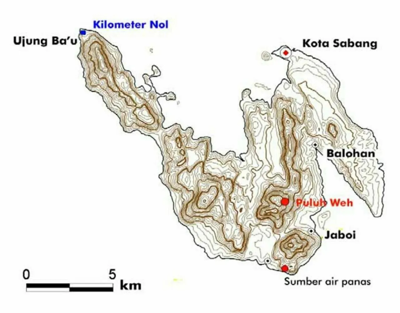
Source image by geomagz.geologi.esdm
A glimpse of the history of the island of Weh
Weh Island is on the westernmost tip of Sumatra Island. This island is included in the administrative area of Aceh Province. Compared to Pulau Weh, tourists are usually more familiar with Sabang.
Rusdi Sufi, one of the Acehnese historians who was also a former guardian lecturer during my college, once mentioned that the island was separated from the mainland. Separation of the island of Weh with the mainland of Sumatra occurred in the era of the Pleistocene millions of years ago.
This is what makes local people call this archipelago an island of Weh, which in Aceh says means the island is off or the island is moving.
"Previously, Weh island was connected to the mainland Ulee Lheue. This also made the city of Banda Aceh called Ulee Lheue, which means head off. That loose head is Weh island," said Rusdi Sufi to me in an interview opportunity for the benefit of the magazine I work for. past.
While Sabang, which is currently the capital for the archipelago, comes from the word Shabag (erupting mountain). If examined from the nature of this island, there are indeed two volcanoes to date. One volcano is in Jaboi.
The information that I searched for mentions that the volcano in Jaboi is also often called Batee Shok. This naming is allegedly derived from the mention of a local person which means empty stone. In this region it looks barren. There are no plants growing there.
Other information says, Jaboi volcano is classified as type C volcano. This means that Jaboi volcano has never erupted and is only a solfatara / fumarola field.
Geographically, this type C volcano is at 5 ° 46 'North Latitude and 95 ° 18' East Longitude. This volcano consists of three solfatara / fumarola fields, each named Lho Balohan Ceunokot, Teupin Kerueng Madun, and Teupin Iboih.
Besides Jaboi volcano, on Weh Island there are also volcanoes under the sea. This volcano is in the Teluk Laot bay area.
However, some experts are more likely to refer to the Men Laot area with fumarola. They more agreed to conclude if the Laot Man was the remnant of a volcano that had erupted. This conclusion is then evidenced by the characteristics that appear in the region, such as the holes of fumarola, solfatar, and hot springs that are common, both on the slopes of the mountain, at the foot of the mountain, on the beach and even on the seabed.
This island group consists of Pulau Weh, Klah, Rubiah, Seulako, and Pulau Rondo, geographically located in the Andaman Sea.
While the geotectonic order is in the western corner of the ring of fire that is still active.
Weh Island stretches for 15 kilometers with an area of 160 km². In the island classification published by UNESCO in 1991, the island is categorized as a small island with an area of less than 2,000 km².
This archipelago which was under the sovereignty of the Aceh Sultanate has often been visited by foreign explorers. This region was even visited by a Greek Earth expert, Ptolomacus, in 301 BC. Ptolomacus then named this region with a gold island. (Need further research).
Other references say, the mention of the golden island for the island of Weh in an ancient voyage map was precisely given by Sinbad in the 12th century AD. He sailed from Sohar, Oman, which took a distant route through the Maldives, Kalkit Island (India), Sri Lanka, Andaman, Nias, Weh, Penang, and Canton (China).
Later, the island of Weh became the charm of the most important sea transportation routes in the Malacca Strait. Especially after the Suez Canal was opened in 1869 AD.
The existence of Weh island in the Malacca Strait is even more important than Temasek (Singapore).
This is what made the Dutch try to invade the sovereignty of the Aceh sultanate which became the ruler of the archipelago in the Malacca Strait.
Later, precisely in 1881, the Dutch were incessantly attacking Aceh, making Sabang a natural port or kolen station.
The Dutch then developed this archipelago as a coal base for the benefit of the Royal Dutch Navy. Later, the Dutch also invited European merchant ships to dock in the region.
In 1887, Firma Delange assisted Sabang Haven to obtain the authority to add and build port facilities and supporting facilities. The free port era in Sabang then began in 1895, known as Vrij Haven and managed by Sabang Maatschaappij.
Before the Dutch controlled the Sabang and Weh islands, the Aceh sultanate concentrated this area into a place of exiles. This is because the island area is very difficult to land so it is less attractive to develop.
However, other sources also mention the Sabang region as the only oldest Hajj embarkation in Southeast Asia controlled by Aceh. Unfortunately, authentic records related to the history of Sabang originating from Malay manuscripts have not been widely published by researchers.
The sun is already falling on the western horizon. I am curious about sea traffic, as conveyed by Zairi, participating in the transportation mode back and forth in the Malacca Strait.
Breaking waves and winds are getting tighter. Twilight blushing drew the curtains of the moonlight, not necessarily extinguishing the Malacca Strait. One, two ships are still visible far away. Vaguely in the darkness of night, the lights of the giant ships caught my eye. At Mata Ie Resort, this is the most memorable experience I have felt: Trying to explore the "time passageway" about what and how Sabang a.k.a Pulau Weh began.
Reading source:
http://geomagz.geologi.esdm.go.id
https://kolonialmonumenten.nl
The Atjeh (Magazin of Aceh)
Note: this paper is dominated by journalistic results by interviewing sources in my work. This article also comes from my subject in the history education department of Unsyiah
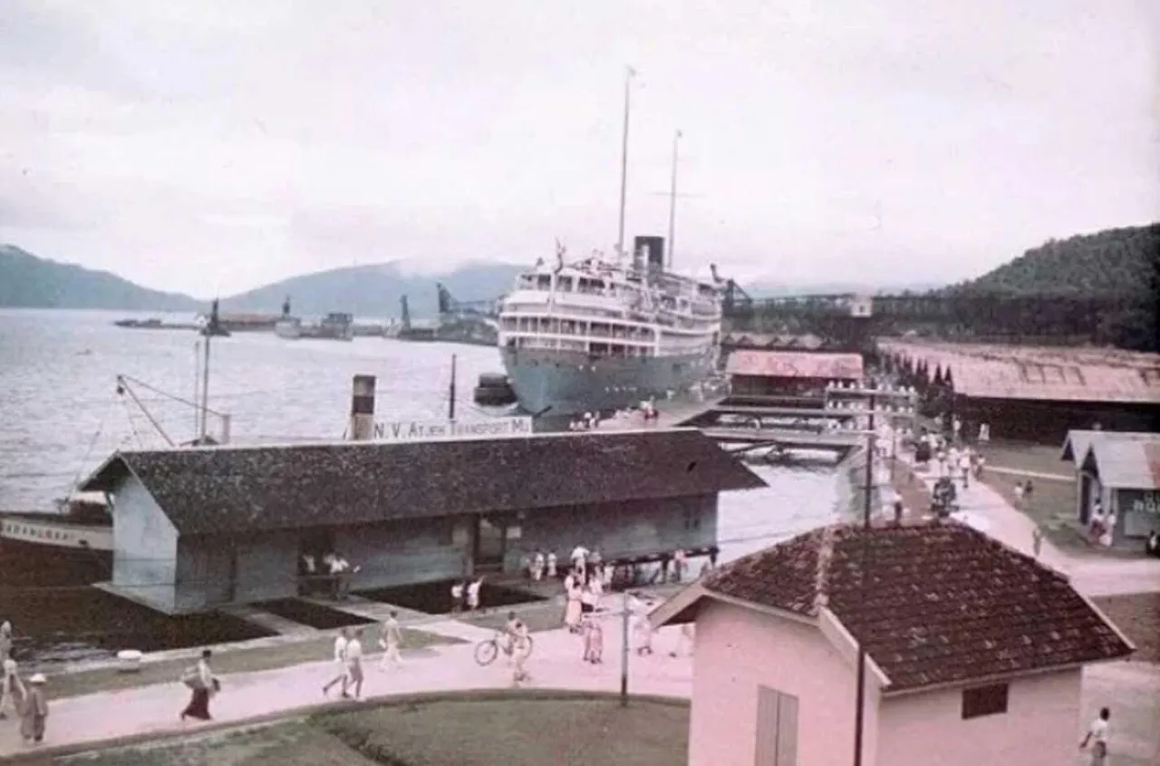
Source image by kolonialmunementen.nl
BAHASA
Seorang pria duduk bersandar di kursi kayu. Satu bungkus rokok kretek merk Dji Sam Soe ditaruh di atas meja. Asbak hijau terlihat penuh dengan puting rokok dan sisa tembakau yang terbakar juga ada di atas meja. Pria itu meraih satu lenting rokok untuk disulut.
"Kletek..." Bunyi pemantik mengeluarkan gas menguap disambut percikan api.
"Fiuhhhh...." Pria itu menghela nafas. Sekumpulan asap tebal keluar dari mulut dan hidungnya.
Dia begitu menikmati aroma kretek buatan asli Indonesia itu. Pria yang sehari-hari berprofesi sebagai jurnalis tersebut kemudian bersuara.
"Sudah tiga yang lewat," kata pria itu kepada saya.
"Apanya bang?"
Ya, saya memanggilnya Bang karena usianya jauh di atas saya. Meskipun tidak pernah bertanya langsung, saya yakin usianya kini nyaris 50 tahun.
"Kapal.. lihat di sana. Tadi kapalnya ada dua beriringan, sekarang ada lagi kapal yang berbeda. Terus nggak terlihat lagi," kata pria itu.
Namanya Zairi. Seorang wartawan di Banda Aceh.
Zairi hari itu begitu menikmati pemandangan laut di lepas pantai Pulau Weh. Berada di lantai 2 Mata Ie Resort, Anoi Hitam, Sabang, akan terlihat jelas garis biru laut nun jauh di sana. Kapal-kapal besar yang hilir mudik di zona ekonomi eksklusif juga mampu tertangkap mata tanpa harus menggunakan teropong.
Saya ikut menemani Zairi. Kebetulan, kami sedang masa rehat dari kegiatan yang digagas Bank Indonesia di Sabang.
Pulau Weh menjadi pilihan kegiatan karena merupakan daerah wisata karena keindahan pantainya jauh lebih bagus dibandingkan Bali.
**Sekilas sejarah pulau Weh**
Pulau Weh berada di ujung paling barat Pulau Sumatera. Pulau ini masuk dalam wilayah administratif Provinsi Aceh. Dibandingkan pulau Weh, wisatawan biasanya lebih familiar dengan Sabang.
Rusdi Sufi, salah satu sejarawan Aceh yang juga mantan dosen wali saya masa kuliah dulu, pernah menyebutkan bahwa pulau tersebut terpisah dari daratan induk. Pemisahan pulau Weh dengan daratan Sumatera terjadi di zaman pleistosen jutaan tahun lalu.
Hal inilah yang membuat masyarakat lokal menyebut daerah kepulauan ini sebagai pulau Weh, yang dalam tutur Aceh berarti pulau minggat atau pulau yang berpindah.
"Dulunya pulau Weh tersambung dengan daratan Ulee Lheue. Ini pula yang membuat wilayah kota Banda Aceh itu disebut Ulee Lheue yang artinya kepala lepas. Kepala yang lepas itulah pulau Weh," ungkap Rusdi Sufi kepada saya dalam suatu kesempatan wawancara untuk kepentingan majalah tempat saya bekerja dulu.
Sementara Sabang, yang saat ini menjadi ibukota untuk daerah kepulauan tersebut berasal dari kata Shabag (gunung meletus). Jika dikaji dari alam pulau ini, memang terdapat dua gunung api hingga saat ini. Satu gunung api itu berada di Jaboi.
Informasi yang saya telusuri menyebutkan gunung api di Jaboi ini juga sering disebut Batee Shok. Penamaan ini diduga berasal dari penyebutan orang lokal yang artinya batu kosong. Di kawasan ini memang terlihat tandus. Tidak ada tanaman yang tumbuh di sana.
Informasi lain menyebutkan, gunung api Jaboi masuk dalam klasifikasi gunung api tipe C. Ini mengartikan gunung api Jaboi tidak pernah meletus dan hanya merupakan lapangan solfatara/fumarola.
Secara geografis, gunung api tipe C ini berada pada 5° 46’ Lintang Utara dan 95° 18’ Bujur Timur. Gunung api ini terdiri dari tiga lapangan solfatara/ fumarola, masing-masing bernama Lho Balohan Ceunokot, Teupin Kerueng Madun, dan Teupin Iboih.
Selain gunung api Jaboi, di pulau Weh juga terdapat gunung api di bawah laut. Gunung api ini berada di kawasan teluk Pria Laot.
Tetapi, beberapa ahli lebih cenderung menyebut kawasan Pria Laot dengan fumarola. Mereka lebih sepakat menyimpulkan jika Pria Laot adalah sisa gunung api yang pernah meletus. Kesimpulan ini kemudian dibuktikan dengan adanya ciri-ciri yang muncul di kawasan, seperti adanya lubang-lubang fumarola, solfatar, dan sumber air panas yang banyak dijumpai, baik di lereng gunung, kaki gunung, di tepi pantai dan bahkan di dasar laut.
Gugusan pulau ini terdiri atas Pulau Weh, Klah, Rubiah, Seulako, dan Pulau Rondo, secara geografis terletak di Laut Andaman.
Sementara secara tatanan geotektonik berada di pojok barat cincin api (ring of fire) yang masih aktif.
Pulau Weh membentang sepanjang 15 kilometer dengan luas 160 km². Dalam klasifikasi pulau yang diterbitkan UNESCO tahun 1991, pulau ini termasuk kategori pulau kecil dengan luas kurang dari 2.000 km².
Wilayah kepulauan yang pada masa dulu berada di bawah kedaulatan Kesultanan Aceh ini sudah sering dikunjungi para penjelajah asing. Wilayah ini bahkan pernah dikunjungi oleh ahli Bumi dari Yunani, Ptolomacus, pada tahun 301 SM. Ptolomacus kemudian menamakan kawasan ini dengan pulau emas. (Butuh penelitian lanjutan).
Referensi lain menyebutkan, penyebutan pulau emas untuk pulau Weh dalam peta pelayaran kuno justru diberikan oleh Sinbad pada abad 12 Masehi. Dia berlayar dari Sohar, Oman, yang mengambil rute jauh dengan melewati Maldives, Pulau Kalkit (India), Sri Langka, Andaman, Nias, Weh, Penang, dan Canton (China).
Di kemudian hari, pulau Weh menjadi pesona jalur transportasi laut paling penting di Selat Malaka. Terutama setelah terusan Suez dibuka pada tahun 1869 Masehi.
Keberadaan pulau Weh di Selat Malaka bahkan jauh lebih penting dibandingkan Temasek (Singapura).
Hal inilah yang membuat Belanda mencoba menginvasi kedaulatan kesultanan Aceh yang menjadi penguasa wilayah kepulauan di Selat Malaka tersebut.
Di kemudian hari, tepatnya tahun 1881, Belanda yang sedang gencar-gencarnya menyerang Aceh, menjadikan Sabang sebagai pelabuhan alam atau kolen stasiun.
Belanda kemudian mengembangkan daerah kepulauan ini sebagai pangkalan batubara untuk kepentingan Angkatan Laut Kerajaan Belanda. Belakangan, Belanda turut mengajak kapal-kapal pedagang Eropa untuk berlabuh di kawasan ini.
Pada tahun 1887, Firma Delange dibantu Sabang Haven memperoleh kewenangan menambah serta membangun fasilitas dan sarana penunjang pelabuhan. Era pelabuhan bebas di Sabang selanjutnya dimulai pada tahun 1895, dikenal dengan istilah Vrij Haven dan dikelola oleh Sabang Maatschaappij.
Sebelum Belanda menguasai wilayah Sabang dan Pulau Weh, kesultanan Aceh justru memusatkan daerah ini menjadi tempat orang-orang buangan. Hal ini dikarenakan daerah kepulauan itu sangat sulit untuk didarati sehingga kurang menarik untuk dikembangkan.
Tetapi, sumber lain juga menyebutkan wilayah Sabang sebagai satu-satunya embarkasi haji tertua di Asia Tenggara yang dikuasai Aceh. Sayangnya, catatan otentik terkait sejarah Sabang yang bersumber dari manuskrip Melayu belum dipublikasi secara luas oleh para peneliti.
Matahari sudah kian rebah di ufuk barat. Saya yang penasaran dengan lalu lintas laut seperti disampaikan Zairi, ikut menikmati hilir mudiknya moda transportasi di Selat Malaka.
Debur ombak dan semilir angin semakin kencang. Senja merona menarik tirai cahaya rembulan, tidak serta merta memadamkan Selat Malaka. Satu, dua kapal masih terlihat nun jauh di sana. Samar-samar di kegelapan malam, cahaya lampu kapal-kapal raksasa tertangkap mata saya. Di Mata Ie Resort, inilah pengalaman paling berkesan yang saya rasakan: Mencoba menelusuri "lorong waktu" tentang apa dan bagaimana Sabang a.k.a pulau Weh bermula.
Catatan: tulisan ini didominasi oleh hasil karya jurnalistik saya dengan mewawancarai sumber dalam kurun waktu berbeda. Tulisan ini juga bersumber dari mata kuliah saya di jurusan pendidikan sejarah Unsyiah