GARMIN FENIX 7 PRO SAPPHIRE SOLAR
GETTING STARTED + MY FIRST CUSTOM ROUTE PLAN
GETTING STARTED
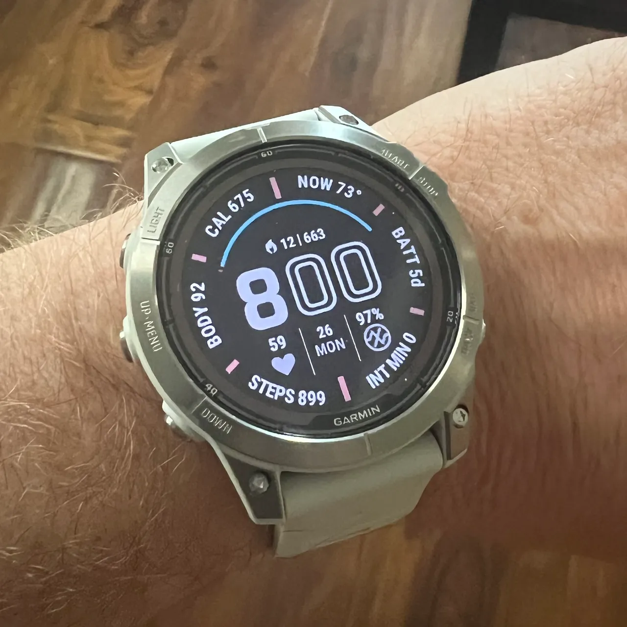
The display has this kind of, low intensity vibe. The colors aren't really popping out, it doesn't look like a glowing magick gem on my wrist...it looks sharp, it looks clean, it looks confidently subtle and respectfully subdued. I really like the Fenix' reflective display - however, if you prefer a brighter OLED display, the Epix is Garmin's answer to your prayer. The Epix is the Fenix, but with OLED instead of reflective display, and from what I can gauge, that's about the only difference in the hardware.
I've been reading up lately, can you tell?
But...what's the point then, if one just looks stunning and the other doesn't??? Who would want the Fenix?
The Fenix' reflective display requires less power, so it was employed here to give this expedition watch something crazy like a month in between charges...but if you're more of a run/bike/charge my watch every night kind of person, you'd most likely find yourself leaning towards the Epix because yeah, no one passes up on a gorgeous display for no good reason.
One thing I found while I was playing with it, is these health snapshots. You start the recording, then sit back and go as zen as possible for two minutes...
...according to Garmin, it's not that intense...just sit still for two minutes is what they actually tell you.
I really am my own worst enemy. Anyway, yeah after two minutes it provides a spreadsheet of measured, counted and calculated vitals and stats...shown below is just the first screen of several. All this can also be viewed from the Connect app.

...this thing is packed with features and tools...even a flashlight that is easy to toggle on off/adjust brightness/switch from white light to red. If people seem interested in reading about the other things I find, I'll keep this going as I find things...but the main thing I wanted to talk about today, is the custom/planned route feature.
RUNNING MY CUSTOM ROUTE
We had dinner downtown on this particular evening. It was good, and now we were on the way home. I was ready to go to bed and capture some sleep data, but had a few things to do around the house first while MaryAnn finished charting her patients for the day.

My boss messaged me as I was picking up around the kitchen. There's an IC test running back at work. It's setup on the floor (in case it were to catch fire). He wants to know if I can come in in the middle of the night or super early in the morning to verify if the integrated circuit chip is still performing as desired.
I'm on my way now. I replied.
I love special missions.
The test passed, so my boss will now be able to have the manufacturing team implement the board level changes that we tested - and because we did it the way we did, he'll have notified them before I even make it home, and they will be able to get started at 0600 hrs.
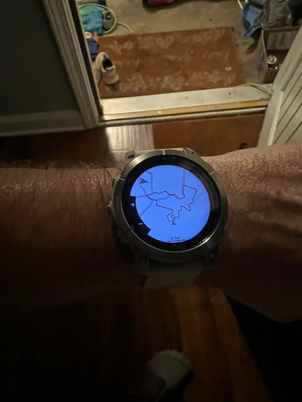
The drive to/from work takes 20-30 minutes. That was enough time for me to remember I had set up a custom route in the Connect app before I'd even gotten the watch - I had been very excited to try it and see how the prompts work, what it's like running a new route with only the map on a watch screen, woo woo woo - and I decided that 0100 hrs was going to be a fine time to dive into my maiden voyage.
I loaded up my home made weighted vest, opened my custom map via the watch's Run menu, and took off.
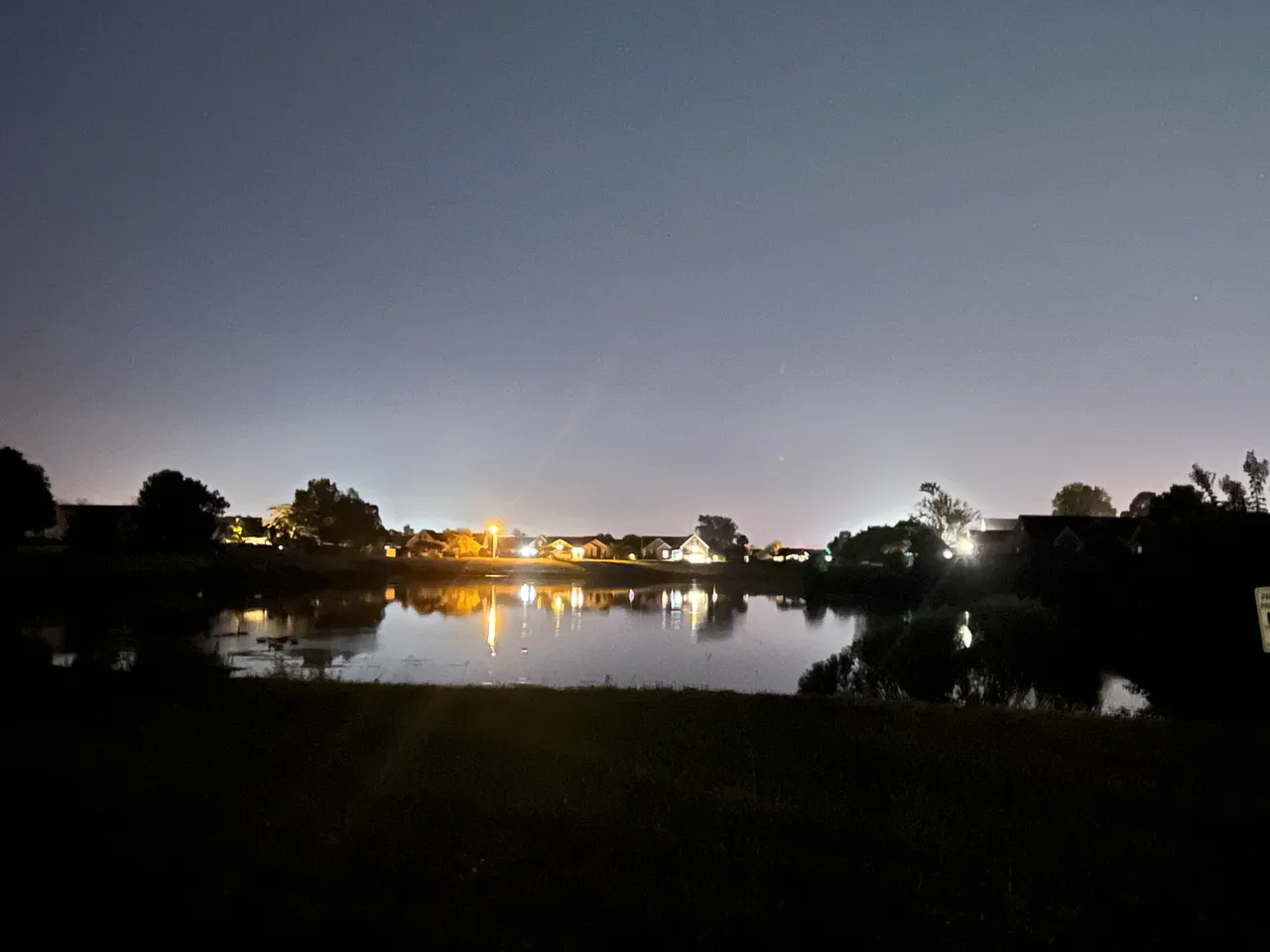
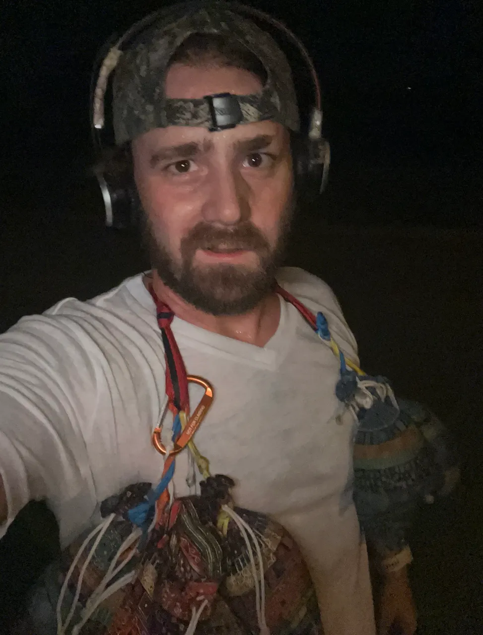
I only took two pictures while I was out. One sweaty selfie, and one across the drainage pond because I thought the reflections people might appreciate this nice scene as much as I did...not that they'll see it, because I'm not posting this in that community...but you saw it, and that's good enough for me...I like you.
Took me about 45 minutes to finish the run, but I didn't realize I hadn't fully stopped the activity until after I'd been home for about 15 minutes.
...I realized it when I went to the connect app, and there was no run saved LOL - which triggered me to remember that I hadn't saved my run.
...I'm Learning...
Anyway, once I saved the activity from the watch interface, it was immediately synchronized into the phone app. The first thing I see when I open the activity log, is this nice little map and some of the front-running statistics you would want for a run...kinda kills me to see the total time at almost an hour...but you and I know what happened, and that'll have to be good enough.
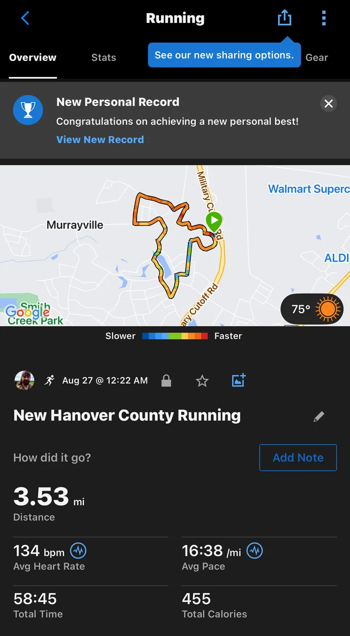
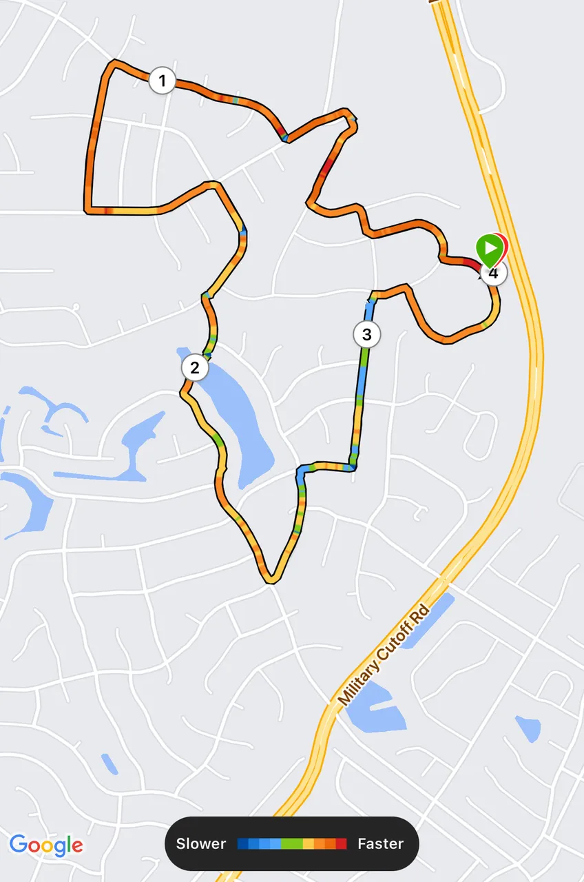
When I dig in, I find a nice detailed map, which outlines the miles in order, and color codes the route according to my speed. Start strong and end strong...as long as you don't push too hard in the middle, I always say LOL
I've literally never said that.
I guess they have their own community sharing kind of thing, so you can add photos from your activity and have them embedded in the activity log...probably won't use that much, but who knows. I tried it this time, and added the two pictures you already saw.

Finally, I found this stats tab, which has just a friggin mountain of data from the run. If you're looking to gain insights from performance data that can be leveraged to elevate your performance, I think this might just be the holy grail of publicly available technology. I'm just gonna slap these three in a table to cut down on size a bit.
| Column 1 | Column 2 | Column 3 |
|---|---|---|
 |  |  |
PLANNING A CUSTOM ROUTE
I don't want to go crazy on this part, but I did find this feature without using an internet search, so I want to at least briefly document the process so I can fall back on this if I forget what I did to build that route.
| Column 1 | Column 2 |
|---|---|
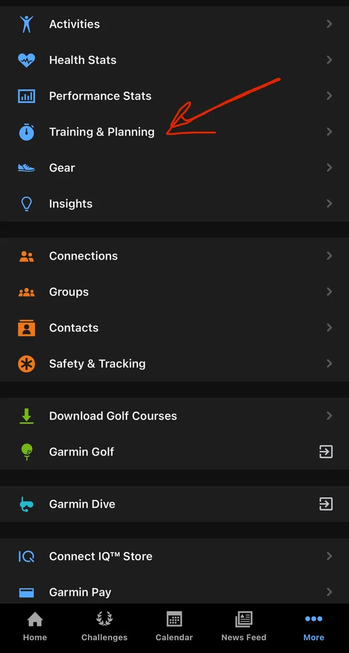 | In the main menu (Connect app), go to Training & Planning. |
 | Select Courses |
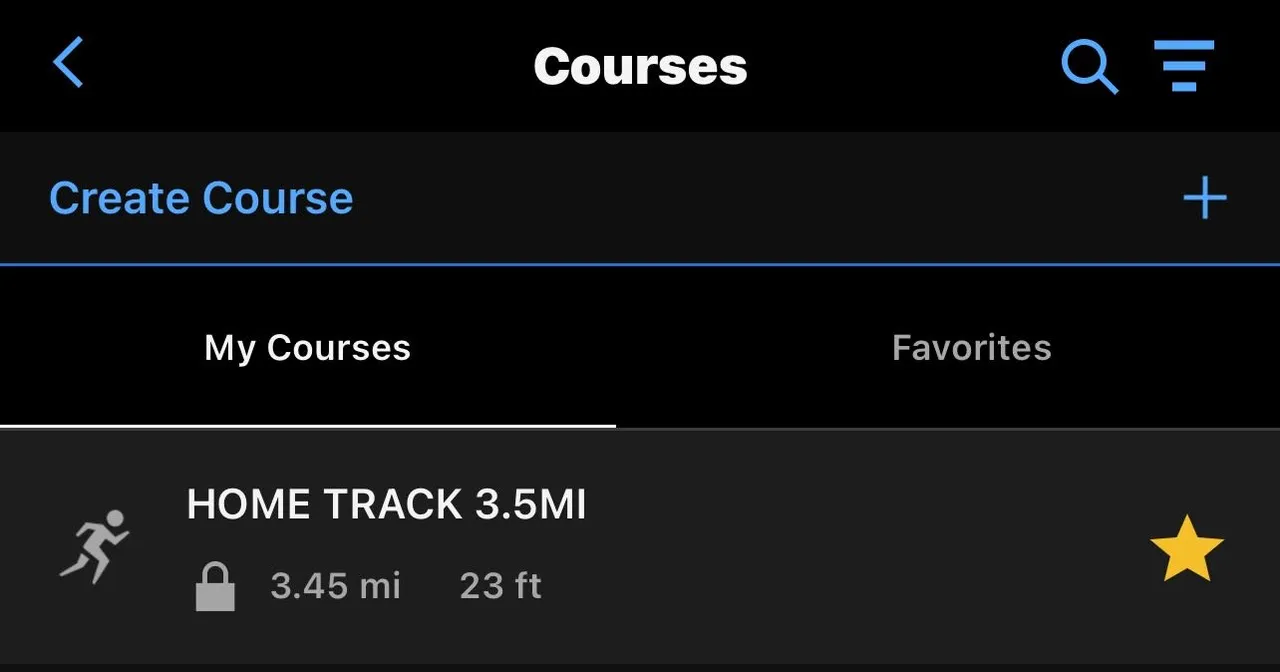 | Here is where you would select to add or modify a course |
There are various options for setting up a course. I dropped way points along the route and the algorithm plotted a course that threaded through them nicely. The prompts on the road were good, even as dark as it got in some places, I generally knew where to turn without looking at the map.
This will be handy for hiking to waterfalls and stuff like that.
SUMMING IT UP
wow, that feels text-bookey...
The run was a success, it was great being able to plan a route of a particular distance and load it onto my watch seamlessly. I look forward to using this feature in less forgiving terrain at some point, but for now I was happy to run a proof of concept/test run kind of activity. I will use this again for future runs.
There are other GPS-based running features as well, and I don't know what they all are - but there's one I think called Follow Me, that just lets you run willy nilly and it records your route on the map. I'm wondering if I can run a Follow Me route and later save it as a custom route to follow...

Thanks for checking out some more of my work! As always, I hope you enjoyed witnessing as much as I enjoyed creating!
© Photos and words by @albuslucimus, except where otherwise indicated.
If you enjoy my content, check out the Albus Index!
Here you’ll find links to various post-groupings, so you can find all posts related to a specific topic quickly. Topics include lists of brewing recipes, flutes, crypto talks, rucking posts and an index of all acoustic covers. The lists are updated as new content is added, so they can always be used to quickly navigate my content.

source
