How would you describe a perfect bike-ride? For me it would be a day-long outing in nature, preferably in beautiful weather. It would have minimal interference by motorist, include some good challenges for the mind and body, but be overall a pleasant ride with lots of amazing things to see, feel, and experience. This past Sunday I went on a ride that included all of this, and was as close to perfection as I can imagine.
Outsmarting the Progressing Berry Season
It all started with a shortage of salmon berries. For the last weeks we’ve been snacking on the incredible abundance of berries I described earlier, but seeing that we're in late July, the salmon berries have gotten quite scarce. Eaten by bears (and us), or just shriveled unpicked in the sun. Their season was over. Sure, the salal berries are starting to ripen, and the thimbleberries are just everywhere. Still, we decided to look for some ripe salmon berries in some higher elevations. A relative of Tony’s also told us about a logging road we could take, that would take us up the headwaters of the Qualicum River, and we’d have a 25 km downhill ride.
Follow Me on SteemitWorldMap:
[//]:# (!steemitworldmap 49.408520 lat -124.833183 long d3scr)
Up Into the Foothills of the Beaufort Mountain Range
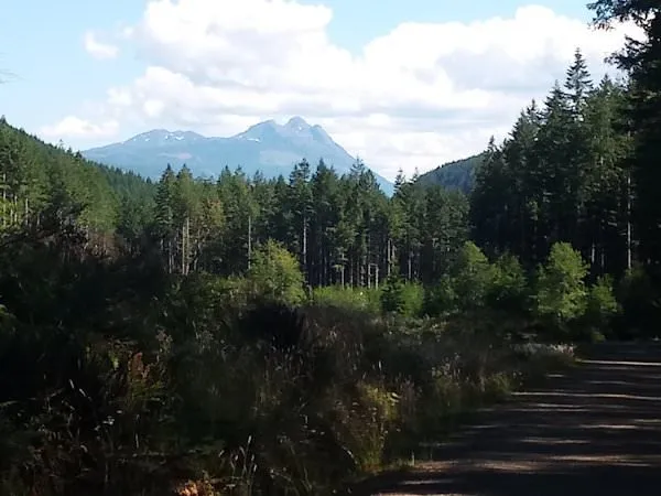
We set out after sleeping in a bit and a leisurely breakfast. At first we followed the Lighthouse Trail passing by the property, then continued on the highway through Bowser and past Deep Bay to Cook Creek Road. That took us past the Inland Highway right into the woods. It was gonna be uphill from here. A gradual climb led into a steeper one, and after getting side-tracked towards Chef Creek (from cook to chef? wrong way!) we found ourselves overwhelmed by the grade. We didn’t have to push for too long though. Eventually the steepness became more manageable and we rode on at a comfortable pace.
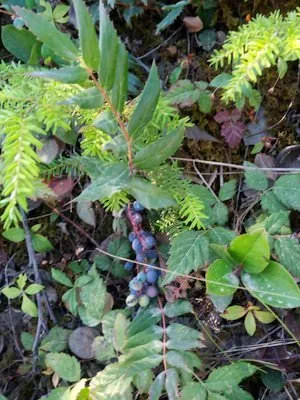
Berry Break

At some point we came to a clearing with a nice place to look down at sea below us. This place also turned out to be a perfect berry-picking spot. We found huge huckleberries, thimbleberries, native blackberries, to our heart’s delight. There were also ripe salal berries (Gaultheria shallon), oregon grapes (Mahonia aquifolium), which were not ripe on our last berry-picking ride. The former is a meaty berry, neither to sweet nor sour, the latter a deliciously sour native blueberry. And just like the four berries I've mentioned here, these two also grow just about everywhere! Most importantly, we found what we’ve come for: ripe salmon berries! Courtesy of the wonderful micro-climate of his sunny clearing on the hillside.

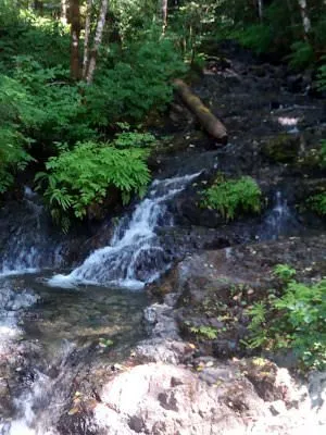
Water All Around Us
After a copious refreshment, we rode on circling the mountain that was still towering behind us. On the way we passed by many little creeks, either crossing under the road, running down the hill, or flowing along our path, going the opposite direction. That was the only thing that reminded us that we were still going uphill. At times we stopped, filled up our bottles from the springs, and partook of more salmon berries growing by the roadside.

Chain Break
Going uphill I completely ignored coming out of granny-gear. The incline was not that steep any more, so I cross-chained, using both of my smallest cogs. Not a good thing to do, as I learned the hard way. Suddenly I noticed that my pedaling was futile: my chain broke. Okay, let’s enjoy the break, eat some huckleberries, and get out the bike-tools. After fumbling around with the chain for a while my fox was back to her old self. And I went back to using the middle gear in front, unless necessary.
Rolling with the Qualicum
Eventually we reached the point where the Big Qualicum River came down the mountain, along with the Roswell Creek, but both their runs were dry. Never mind, there were plenty of other tributaries feeding into it, and not long after our downhill start the Qualicum was splashing happily along with us down the hill. By the way, the name Qualicum (Qualicum Bay, Qualicum Beach, Qualicum First Nation, Big and Little Qualicum Rivers) comes from the Qualicum wind, a warm current being pushed out of the valley around Port Alberni. At this point we were on a very gradual decline, just rolling downhill, pedaling only to keep us going. We kept stopping for berries, and the occasional dip in the cool (no, actually really cold!) waters of the mountain stream. In the distance we could see Mount Horne.
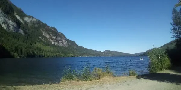
Horne Lake
The Qualicum River runs into Horne Lake, so that’s where our trip took us. The gorgeous, but immensely cold pools of the Qualicum were hardly frequented by visitors. Once we reached the lake however, there were RVs, camper-vans, family-vans, boat trailers, and all such stuff around us. Sure, the lake doesn’t look too shabby either. We enjoyed it for a while, then rode on. Riding along the lake was not bad, except for the traffic. Okay, it’s not the Inland Highway, but the dirt-road gets very dusty after an SUV passes. Fortunately there was another, more fun way home, ours to be discovered.
A Road Just for Us
Turning off of Horne Lake Road we came across a closed gate: It was a hiking trail big enough for motorists, but closed for traffic due to fire hazard. Since our bikes don’t operate on flammable stuff, we felt safe enough to proceed. It was no big deal lifting them through the gate. What awaited us on the other side was more downhill ride through the forest, passing along waterfalls and gently rolling shores of the Qualicum. And it went on and on, without anyone around! Eventually we passed under the Inland Highway, and came out at the Qualicum First Nation Fish Hatchery, right next to the railroad trestle.

The Last Leg by Train
I mentioned this trestle in my post about walking around in the rain (and winning at the meat draw). It is only a few minutes from the property, so there could be a way to avoid riding home on public roads all together. Of course, this meant that we had to ride on the train track. Why not? Long defunct, many of the ties had so much dirt and moss accumulated between them that you could ride on them… almost. Occasionally we sounded, and felt like a choo-choo train, bumping along those ties. The funniest part of it all was crossing the trestle itself. No railing, nothing between the ties, and it goes down… quite far! Once we made it to the property, I got off the tracks and promised my fox not to subject her to train-tracks again.

Looking back at it, the ride had been ideal in every aspect. Strava recorded 69 km (43 miles) distance covered, with a cumulative elevation gain of 1119 m (3700 ft) in about 5:30 hours. In reality we left at 10 a.m. and got back at 7 p.m. Although it was a relaxing day, we felt pleasantly exhausted, and although we’d been eating berries all day, we were righteously famished. This trip would set the standard pretty high for subsequent bike-rides, which I of course intend to surpass.
Take a Look at my other Bike-Trips I Took on Vancouver Island:
- Bike Tour on the Cowchian Valley Trail
- Fernwood in the Sunshine
- Hunting for Cultures
- Midnight Mystery Moon Ride in Victoria
- Journey Across Salt Spring Island to Chemainus
- Chemainus to Qualicum Bay
- Oyster Run to Fanny Bay
- My Vancouventure
- Magical Lasqueti Tour
Please check out these great communities I'm contributing to:

#homesteadersonline | Website | Discord Community

#ecotrain | What is EcoTrain | Discord Community
#cyclefeed | Introducing CycleFeed | Discord Community

Introducing SteemitDreamit | Facebook Group | Discord Community