Tropical Flow Breaks Down Briefly Next Week Before Returning

Tropical Flow Breaks Down Briefly Next Week Before Returning

The upper air flow in the Eastern United States has been a stubborn on and as the satellite picture above shows, the issue of the trough that lies through the Gulf States and into the Gulf of Mexico remains a huge issue. Off the East Coast is a strong upper high and the resulting winds in the upper atmosphere continue to pump tropical mositure from the Caribbean northward. This plays through this weekend but the ridge does flatten out somewhat for a few days next week. This at least gets air masses moving and it does weaken that tropical connection.
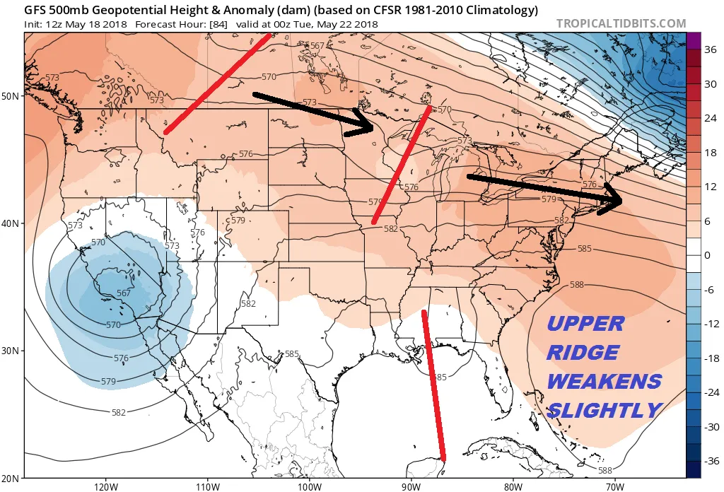
GFS UPPER AIR JET STREAM TUESDAY MAY 22, 2018

The problem with this northern jet stream taking over is that there are weather systems moving along in the flow that will bring cold fronts through every couple of days and those could produce some showers or a thunderstorm. Tuesday and Tuesday night look like an opportunity for showers. After that the tropical connection appears again later next week. This could be a bit more intriguing as pressures over the Caribbean will be low and this could spark a low to develop. It is early but a tropical system developing in the Northwest Caribbean later next week is not impossible. We mentioned yesterday that weather models all seem to show this idea in one form or another which in my view raises the confidence level in models.
GFS SURFACE THURSDAY MAY 24, 2018

Climatology would argue against development even in the NW Caribbean where most early season storm forms. Water temperatures in the Gulf of Mexico are not all that warm at the moment which would not be too supportive for anything to develop and strengthen. However the troughing in the upper atmosphere in the Gulf of Mexico and a relatively low wind shear environment would be supportive. Whether it develops or not the moisture and pattern would argue for more wet weather in the East late next week and next weekend which is the Memorial Day holiday weekend and the unofficial kickoff of the summer vacation season. We will continue to watch and see how this plays out over the next several days.
<iframe style="border: none; overflow: hidden;" src="https://www.facebook.com/plugins/post.php?href=https%3A%2F%2Fwww.facebook.com%2Fmeteorologistjoecioffi%2Fposts%2F10160521786515387&width=500" width="500" height="484" frameborder="0" scrolling="no"></iframe>
MANY THANKS TO TROPICAL TIDBITS FOR THE WONDERFUL USE OF THE MAPS

GET JOE A CIGAR IF YOU LIKE!
FiOS1 News Weather Forecast For Long Island
FiOS1 News Weather Forecast For New Jersey
FiOS1 News Weather Forecast For Hudson Valley
NATIONAL WEATHER SERVICE SNOW FORECASTS
LATEST JOESTRADAMUS ON THE LONG RANGE
<script type="text/javascript"> amzn_assoc_placement = "adunit0"; amzn_assoc_search_bar = "true"; amzn_assoc_tracking_id = "meteorologisj-20"; amzn_assoc_search_bar_position = "bottom"; amzn_assoc_ad_mode = "search"; amzn_assoc_ad_type = "smart"; amzn_assoc_marketplace = "amazon"; amzn_assoc_region = "US"; amzn_assoc_title = "Shop Amazon Via JOESTRADAMUS for anything. Just Use The Search Box"; amzn_assoc_default_search_phrase = "fishing gear"; amzn_assoc_default_category = "All"; amzn_assoc_linkid = "400feb49ec86e057a1495ab9f8e2ac47"; </script> <script src="//z-na.amazon-adsystem.com/widgets/onejs?MarketPlace=US"></script>Posted from my blog with SteemPress : http://www.meteorologistjoecioffi.com/index.php/2018/05/18/tropical-flow-breaks-down-briefly-next-week-before-returning/