Weather Models Aggressive For Middle Atlantic & Northeast Tuesday Wednesday

Weather Models Aggressive For Middle Atlantic & Northeast Tuesday Wednesday
Somebody needs to tell the atmosphere that we have had enough with these winters storms this month. Weather models continue to zero in and tighten up regarding the developing complex storm over the Middle Atlantic & southern areas of the Northeast US for Tuesday and Wednesday. There is a lead low that comes out on Tuesday and produces precipitation across Central and South Jersey south and southwestward but the bulk of the snow comes Wednesday as a second low develops and intensifies fairly rapidly to just east of the New Jersey coast Wednesday afternoon and evening. There is plenty of cold air around (relative to the time of year). Forecasting accumulations is going to be a challenge since terrain, elevation, coastal exposure and the sun angle are all going to be in play here. So is the colder ground as temperatures the last several days have been cold especially at night so this ads another variable. Warmer urban locations will be very tough to figure as far as snow amounts are concerned.

This map shows the total liquid precipitation amounts as generated by today's NAM model. If we went literally 10 to 1 ration we would be talking some pretty hefty amounts but we do not feel comfortable forecasting 20 inches of snow based on 2 inches of rain on the first day of spring due to the variables mentioned earlier. Also some of this precipitation will fall as rain and sleet which cuts back on amounts. This is way that at least for now we have gone more conservative. Bear in mind that there will be variability across the entire region.
JOE'S SNOW FORECAST MAP TUESDAY WEDNESDAY MARCH 20-21 2018

What makes this even more complicated is that there is that lead low that develops on Tuesday into Tuesday night that will produce snow sleet and rain so we need to work that into the equation. The main hit is going to be Wednesday for much of the area.
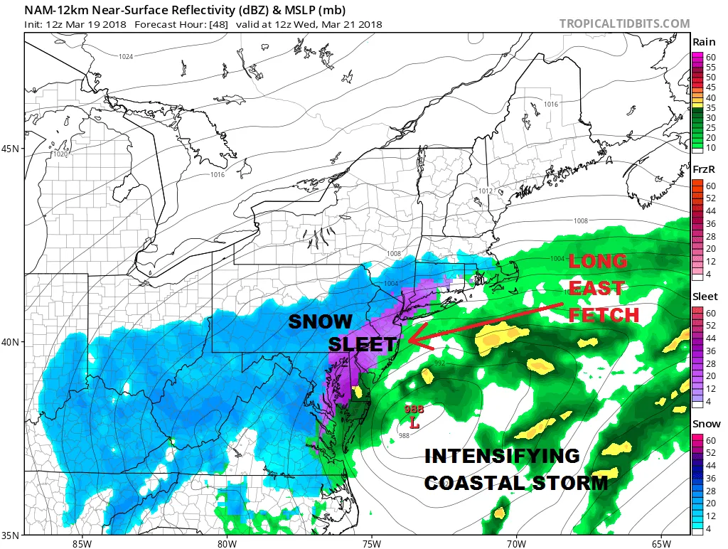
NAM MODEL WEDNESDAY MORNING MARCH 21, 2018

Sleet could be a big issue Wednesday morning north and west of the low center. The NAM is pretty aggressive with an area of sleet which of course cuts down total snow accumulations in terms of ratios. Eventually cold air overtakes it all and the entire area changes over to snow Wednesday morning and snow continues into Wednesday night before tapering off and ending.
With respect to coastal flooding there will be a long easterly fetch that develops Tuesday and lasts into Wednesday so this could mean coastal flooding issues for Southern New England south to the Delaware coast at the high tides later Tuesday into Wednesday until the winds shift to the north and northwest.
NAM MODEL WEDNESDAY EVENING 8PM MARCH 21, 2018

Snow should be tapering and ending Wednesday night and weather conditions will improve on Thursday. I'm expecting winter storm watches to go up later today for some areas. An early look at the GFS & RGEM models line up fairly well with the NAM model so confidence is growing.
NATIONAL WEATHER SERVICE SNOW FORECAST MAPS ARE UP AND UPDATED HERE
SHOP THE JOESTRADAMUS STORE
<iframe style="border: none; overflow: hidden;" src="https://www.facebook.com/plugins/post.php?href=https%3A%2F%2Fwww.facebook.com%2Fmeteorologistjoecioffi%2Fposts%2F10159926287540387&width=500" width="500" height="482" frameborder="0" scrolling="no"></iframe>
MANY THANKS TO TROPICAL TIDBITS FOR THE WONDERFUL USE OF THE MAPS

GET JOE A CIGAR IF YOU LIKE!
FiOS1 News Weather Forecast For Long Island
FiOS1 News Weather Forecast For New Jersey
FiOS1 News Weather Forecast For Hudson Valley
NATIONAL WEATHER SERVICE SNOW FORECASTS
LATEST JOESTRADAMUS ON THE LONG RANGE
<iframe style="border: none;" src="//rcm-na.amazon-adsystem.com/e/cm?o=1&p=12&l=ur1&category=gold&banner=1XD8WGXBAZC9QME1TFG2&f=ifr&lc=pf4&linkID=89e731526985455dfa8b4e7a2a920caa&t=meteorologisj-20&tracking_id=meteorologisj-20" width="300" height="250" frameborder="0" marginwidth="0" scrolling="no"></iframe>
Posted from my blog with SteemPress : http://www.meteorologistjoecioffi.com/index.php/2018/03/19/weather-models-aggressive-for-middle-atlantic-northeast-tuesday-wednesday/