HURRICANE FLORENCE CONTINUES HISTORIC MARCH
Good afternoon everyone. Hurricane Florence continues her march towards the Carolina coast as a Category 4 storm and she's packing 130+mph winds and 160mph gusts. Concerns are growing about flooding potential and coastal impact as models agree she will really slow down once encountering land/shore.
WESTERN ATLANTIC SATELLITE

Hopefully everyone in the area is listening to their local officials and local meteorologists to leave specific areas which may see life threatening, catastrophic damage and/or moderate to heavy property damage. Your presence cannot stop the power of nature and will do nothing to help the situation if it deteriorates. Your presence will also put first responders lives in danger, and take away assets in place for the response after Florence leaves.
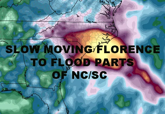
After landfall, widespread heavy/catastrophic flooding will be a wide-ranging issue for interior parts of North Carolina and South Carolina. Where Florence goes and how slow will determine who will be at risk and for what. Do not rely on rain maps generated today, to make your decisions Friday or Saturday. Stay tuned to your local weather and be guided by the final direction of Florence. If you are at the coast, or slightly inland in lowland areas near creaks and bays connected to the larger bays/ocean, NOW is the time to prepare and leave.

To the left is a model run depicting the landscape for Florence's arrival early Friday. To the right is a map I generated August 31st as I warned that the tropics were going to heat up and heat up fast. The onshore flow and high pressure to the north protect the NYC area, but puts the southeast at risk for a landfalling hurricane if one existed.
Fortunately, after this we return to a somewhat quiet period in the short range. Helene is moving out to sea and Issac will weaken into nothing noteworthy. However, for the rest of our tropical season, we will begin closely watching the gulf, lower caribbean, and any old fronts that get hung up along the coast. Those risks are typically the type we see later into the hurricane season.
Stay tuned for more updates on Hurricane Florence.
FiOS1 News Weather Forecast For Long Island
FiOS1 News Weather Forecast For New Jersey
FiOS1 News Weather Forecast For Hudson Valley
NATIONAL WEATHER SERVICE SNOW FORECASTS
JOIN JOESTRADAMUS ON YOUTUBE!
LATEST JOESTRADAMUS ON THE LONG RANGE
amzn_assoc_placement = "adunit0"; amzn_assoc_search_bar = "true"; amzn_assoc_tracking_id = "meteorologisj-20"; amzn_assoc_search_bar_position = "bottom"; amzn_assoc_ad_mode = "search"; amzn_assoc_ad_type = "smart"; amzn_assoc_marketplace = "amazon"; amzn_assoc_region = "US"; amzn_assoc_title = "Shop Amazon Via JOESTRADAMUS for anything. Just Use The Search Box"; amzn_assoc_default_search_phrase = "fishing gear"; amzn_assoc_default_category = "All"; amzn_assoc_linkid = "400feb49ec86e057a1495ab9f8e2ac47";Posted from my blog with SteemPress : https://www.nycweathernow.com/hurricane-florence-continues-historic-march/