FLORENCE WATCH CONTINUES TROPICS WHITE HOT
Good morning everyone. We have a rainy forecast ahead for the New York City area, plus eyes continue to watch what-will-be Hurricane Florence again as it treks towards the East Coast. There are some important agreements happening, but also some disagreements in the models that can't be ignored in terms of who can breathe a sigh of relief or not.
To start, we have some light showers in the NYC area this morning. Things should taper off as we go on, but clouds and the slight chance of a shower will stock around, highs near 70. Tomorrow, we introduce rain into the area a little earlier than expected as a front containing Gordon's remnants moves in. That also means what was supposed to be a cool day will be even cooler. Expect the chance of steady rain by late morning/early afternoon, a brisk NE breeze, and highs only in the mid to upper 60's.
Gordon and it's buddy frontal boundary stick around for Monday, giving us steady rain and a few rumbles of thunder into overnight Monday. We'll be on the humid side of things Monday as we recover back into the 70's. After that, tropical air moves back in with a very warm and humid Tuesday and Wednesday; with mid to upper 80's and the chance of an afternoon storm each day. I'm not going beyond Wednesday at this point, because everything hangs on the actions of Florence, which I discuss below.....
WESTERN ATLANTIC SATELLITE

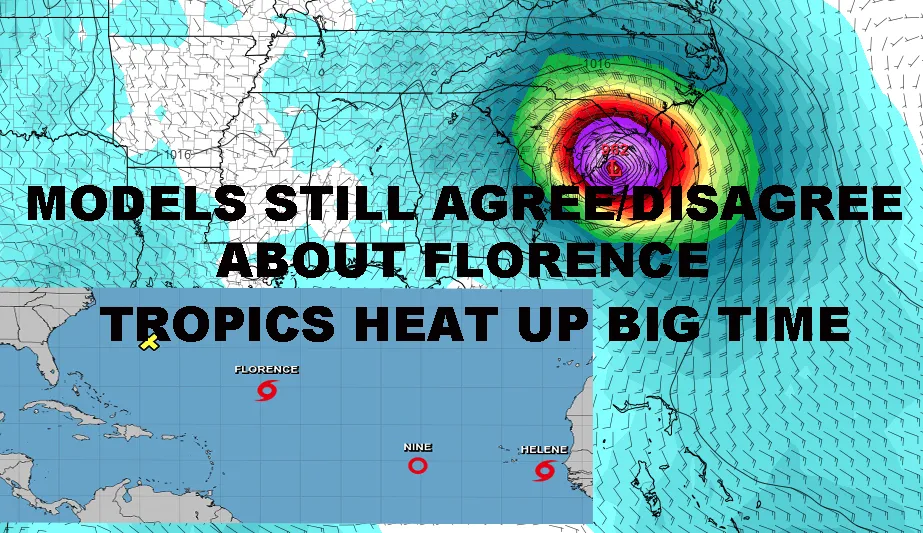
The tropics are really starting to heat up now, with Tropical Storm Helene forming off of Africa, and Tropical Depression #9 ahead of it. While both system obviously need to be watched, we have a long way to go with either, so the focus remains on the immediate threat, which is Florence.
Florence is looking very healthy this morning and should be a hurricane again between the time I'm typing this to sometime mid-afternoon. One of my concerns with Florence is that her effects may be far-reaching, something not discussed by many. When hurricanes weaken, the wind field typically spreads out a bit; which is what we saw happen to Florence as wind shear weakened her. Now that she's getting herself back together, the wind field and overall structure remains somewhat large. This gives her the opportunity to become a much larger hurricane size-wise than she was originally. What this means for us is that IF she makes landfall, a fairly large swath of land could see tropical storm force winds.
As far as models are concerned, the initial area of concern continues to be the Carolina's. Both our EURO and GFS agree that Florence will be a major hurricane sitting somewhere off of the Carolina's between Cape Hatteras and the Charleston, SC area. This gives us enough to be very concerned for that region; however, we cannot take our eyes off of the ball in terms of the rest of the east coast due to disagreements after that initial window.
While the EURO slams Florence into the Southeast Coast and inland, the GFS remains stubborn; having Florence come to a screeching halt by Cape Hatteras, then wobbling, moving north, then out to sea. Because of this, I don't think Virginia to New England can breathe a sigh of relief yet. I want to see more agreement in the models before I start telling people they can bring their guard down.
I remain firm that tomorrow will give us our best picture in terms of where we will be able to narrow our focus.
*Please consult your local National Weather Service office at weather.gov for the latest information on any tropical storms or hurricanes that could be a threat to your area. Consult your local government officials regarding action you may need to take to secure life and property. Maps shown on here SHOULD NOT be used for decision making.
FiOS1 News Weather Forecast For Long Island
FiOS1 News Weather Forecast For New Jersey
FiOS1 News Weather Forecast For Hudson Valley
NATIONAL WEATHER SERVICE SNOW FORECASTS
JOIN JOESTRADAMUS ON YOUTUBE!
LATEST JOESTRADAMUS ON THE LONG RANGE
amzn_assoc_placement = "adunit0"; amzn_assoc_search_bar = "true"; amzn_assoc_tracking_id = "meteorologisj-20"; amzn_assoc_search_bar_position = "bottom"; amzn_assoc_ad_mode = "search"; amzn_assoc_ad_type = "smart"; amzn_assoc_marketplace = "amazon"; amzn_assoc_region = "US"; amzn_assoc_title = "Shop Amazon Via JOESTRADAMUS for anything. Just Use The Search Box"; amzn_assoc_default_search_phrase = "fishing gear"; amzn_assoc_default_category = "All"; amzn_assoc_linkid = "400feb49ec86e057a1495ab9f8e2ac47";Posted from my blog with SteemPress : https://www.nycweathernow.com/florence-watch-continues-tropics-white-hot/