Spring Weather Volatility Continues Next Week Cool Pattern Ahead

Spring Weather Volatility Continues Next Week
Cool Pattern Ahead
We have been advising and continuing to advise that you take advantage of the warm days ahead of us into Saturday because they are short lived, and next week is promising to be cool all week. Sandwiched in between will be a heavy rain event late Sunday into Monday as a strong cold front approaches.
FRIDAY'S FORECAST HIGH TEMPERATURES

SATURDAY'S FORECAST HIGH TEMPERATURES

First off a reminder that Friday and Saturday most areas will be in the 70s. Some 80 degree readings are possible inland. Along the coast the sea breeze will put a cap on the highs. The most important factor for Saturday was the back door cold front to the north that will come through Saturday night. It appears it will not be moving through during the day Saturday which would have impacted temperatures on Long Island and Southern New England. It looks safe at this point.
GFS FORECAST SUNDAY APRIL 15, 2018 8PM

Sunday during the day will be raw and cloudy with some light rain coming in from off the ocean or some patchy steady rain in some places. Temperatures are going to be very raw on Sunday along the coast with some areas not out of the 40s. Inland it could be a bit warmer but 50s to near 60 should be the cap. Sunday night heavy rain will begin to move in from the west and that will carry us into Monday afternoon.
GFS FORECAST MONDAY APRIL 16, 2018 8AM

Low pressure heads to the Great Lakes and weakens while a second low forms right at whats called the point of occlusion where the 3 fronts meet. This is usually the focal point for some heavy rains and thunderstorms and this will play through Monday. 2 to 3 inches of rain is likely in a large area across Pennsylvania and upstate NY with 1 to 2 inches likely on either side.
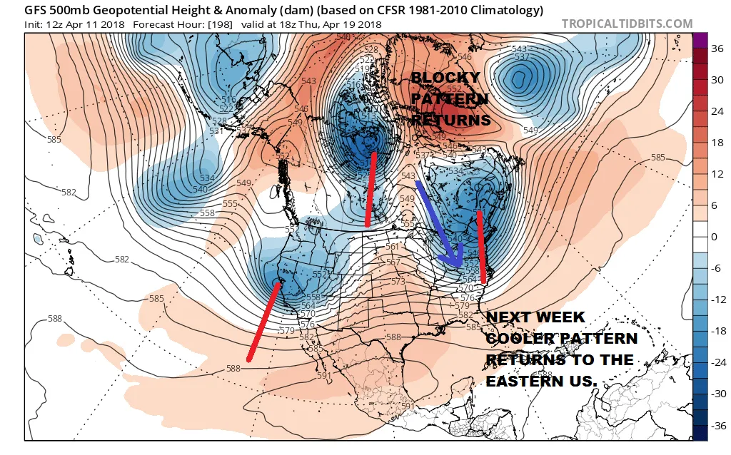
UPPER AIR JET STREAM FORECAST THURSDAY APRIL 19, 2018

Next week the upper air pattern takes on a blocky look to it again with a weak high over Northeastern Canada/Greenland which locks up a vortex in Eastern Canada. This is going to create a rather cool flow of air but there does not appear to be anything in the flow that would be too problematic. Eventually energy from the west coast will eventually move to the east. Much of next week should be dry except for whatever happens on Monday and perhaps the chance for showers late Wednesday with a cold front. Otherwise there are no major weather systems on the horizon.
SHOP THE JOESTRADAMUS STORE
<iframe style="border: none; overflow: hidden;" src="https://www.facebook.com/plugins/post.php?href=https%3A%2F%2Fwww.facebook.com%2Fmeteorologistjoecioffi%2Fposts%2F10160293154820387&width=500" width="500" height="547" frameborder="0" scrolling="no"></iframe>
MANY THANKS TO TROPICAL TIDBITS FOR THE WONDERFUL USE OF THE MAPS

GET JOE A CIGAR IF YOU LIKE!
FiOS1 News Weather Forecast For Long Island
FiOS1 News Weather Forecast For New Jersey
FiOS1 News Weather Forecast For Hudson Valley
NATIONAL WEATHER SERVICE SNOW FORECASTS
LATEST JOESTRADAMUS ON THE LONG RANGE
<iframe style="border: none;" src="//rcm-na.amazon-adsystem.com/e/cm?o=1&p=12&l=ur1&category=gold&banner=1XD8WGXBAZC9QME1TFG2&f=ifr&lc=pf4&linkID=89e731526985455dfa8b4e7a2a920caa&t=meteorologisj-20&tracking_id=meteorologisj-20" width="300" height="250" frameborder="0" marginwidth="0" scrolling="no"></iframe>
Posted from my blog with SteemPress : http://www.meteorologistjoecioffi.com/index.php/2018/04/11/spring-weather-volatility-continues-next-week-cool-pattern-ahead/