April Snow Cheap Thrill Winter Hangs Tough

April Snow Cheap Thrill Winter Hangs Tough
Back in March of 1996 coming off one of the snowiest winters ever we were not done for the season. 3 snow events impacted our area in different ways including a localized one foot snowfall mid month on Long Island. I mention this because it has and does happen. Since March was insane, it would stand to reason that there may be more chances ahead and the first chance comes on Monday with your Easter Sunday dinner not even completed digested.
NAM MODEL MONDAY APRIL 2, 2018 8AM

I'm showing the NAM model surface map for Monday morning and it should be noted that all weather models are showing this. We have a cold front coming through Saturday night. The front stalls and we get a wave on the front. A little bit of overrunning and you have a fast precipitation event that begins during the early morning hours on Monday and then it moves out before mid morning or lunch time at the latest. Cold air is borderline though it is colder aloft. This could be a coating to a couple of inches but it also probably all but disappears once we get past 9 or 10am given the time of year and the sun angle.
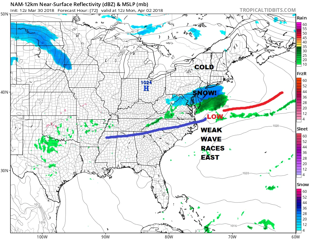
NAM MODEL JET STREAM MONDAY APRIL 2, 2018

Unlike the March noreasters however there isn't much to this first event. The flow is fast from the west and the upper air disturbance that is causing this is nothing to write home about. It will be a matter of how precipitation can this system grind out. The borderline atmosphere probably argues for some nice size wet flakes. The setup argues for the highest amounts to be south of NYC and across Southeastern Pennsylvania and Central and Southern Jersey. Liquid precipitation amounts amount to less than a quarter of an inch to the north but with up to half an inch of liquid to the south.
GFS PRECIPITATION FORECAST THROUGH MONDAY

Another system approaches on Tuesday and Wednesday which will be another warm front cold front combinations which means a chilly rain developing Tuedsay and 60 or better returns on Wednesday. Cold air comes in behind it and then another cold front arrives on Friday, stalls out, and then another wave develops on it for Friday night and into the weekend. That could be another rain or snow event but at this point we let the first one play out. The good thing about April snow is that IF it happens, it melts very fast. As far as the first system for Monday morning is concerned, we will put out some sort of guess on this either tonight or first thing Saturday morning. Just enjoy your holiday weekend in the meantime.
SHOP THE JOESTRADAMUS STORE
<iframe style="border: none; overflow: hidden;" src="https://www.facebook.com/plugins/post.php?href=https%3A%2F%2Fwww.facebook.com%2Fmeteorologistjoecioffi%2Fposts%2F10160293154820387&width=500" width="500" height="547" frameborder="0" scrolling="no"></iframe>
MANY THANKS TO TROPICAL TIDBITS FOR THE WONDERFUL USE OF THE MAPS

GET JOE A CIGAR IF YOU LIKE!
FiOS1 News Weather Forecast For Long Island
FiOS1 News Weather Forecast For New Jersey
FiOS1 News Weather Forecast For Hudson Valley
NATIONAL WEATHER SERVICE SNOW FORECASTS
LATEST JOESTRADAMUS ON THE LONG RANGE
<iframe style="border: none;" src="//rcm-na.amazon-adsystem.com/e/cm?o=1&p=12&l=ur1&category=gold&banner=1XD8WGXBAZC9QME1TFG2&f=ifr&lc=pf4&linkID=89e731526985455dfa8b4e7a2a920caa&t=meteorologisj-20&tracking_id=meteorologisj-20" width="300" height="250" frameborder="0" marginwidth="0" scrolling="no"></iframe>
Posted from my blog with SteemPress : http://www.meteorologistjoecioffi.com/index.php/2018/03/30/april-snow-cheap-thrill-winter-hangs-tough/