Gusty Winds Diminish Dry Thursday Rainy Raw Gloomy Friday


DOWNLOAD MY NEW FREE JOESTRADAMUS WEATHER APP FOR ALL DEVICES


(Unsupported https://www.facebook.com/plugins/post.php?href=https%3A%2F%2Fwww.facebook.com%2Fmeteorologistjoecioffi%2Fposts%2F10161727197790387&width=500)

THE APP IS ABSOLUTELY FREE TO ALL BUT CONSIDERING SUBSCRIBING TO PATREON FOR A WEATHER EXPERIENCE FREE OF ADS, EXCLUSIVE VIDEOS FOR MEMBERS ONLY AND MUCH MORE...STARTS AT $2 A MONTH..MESSAGE ME AT ANY TIME

(Unsupported https://www.facebook.com/plugins/post.php?href=https%3A%2F%2Fwww.facebook.com%2Fmeteorologistjoecioffi%2Fposts%2F10161417866420387&width=500)

Gusty Winds Diminish Dry Thursday Rainy Raw Gloomy Friday

We were blowing away on westerly winds during the afternoon and evening and while it remains rather gusty outside winds will be easing tonight. The major storm that developed to our east Wednesday night is now moving away in Eastern Canada. Winds will continue to diminish overnight and the satellite loop shows cloud free conditions continuing all night. We had the warmest day of the spring so far as highs reached the low and mid 60s on Long Island today and we will be dropping into the upper 30s to near 40 by morning which by recent standards is not all that cold.
EASTERN SATELLITE
storm free

REGIONAL RADAR
storm free

Thursday is shaping up to be a dry day with sunshine most of the day though some high clouds will be around from time to time. Late in the afternoon and evening more clouds will start coming in from the west. Temperatures Thursday will be a little lower than today with highs in the 50s to near 60. Local sea breezes will develop keeping shore areas and Suffolk County cooler in the afternoon. Then Thursday night the onshore flow kicks in and clouds thicken up setting us up for a rather raw day on Friday. High temperatures on Friday will be in the low to mid 40s at best.
Gusty Winds Diminish Dry Thursday Rainy Raw Gloomy Friday

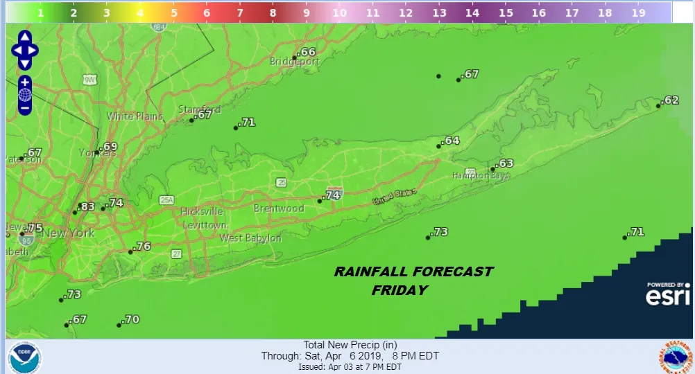
Rain will be an issue on Friday with some rain possibly clipping us in the morning but we will likely wait until later in the day into Friday night for a steady rain. Rainfall amounts will be in the 1/2 to 3/4 inch range. The rains should end during the early morning hours on Saturday as the weather system moves on through.

Gusty Winds Diminish Dry Thursday Rainy Raw Gloomy Friday

On to the weekend which we will label as decent. Leftover clouds Saturday morning will give way to some sunshine and highs should reach the 60s in most places. Sunday starts with sunshine but gives way to arriving clouds as the next weather system heads our way. Temperatures will be in the 50s to near 60 Sunday as winds off the ocean begin again. We are setting up for another repeat performance of an onshore flow and raw wet conditions for Sunday night and Monday.

Gusty Winds Diminish Dry Thursday Rainy Raw Gloomy Friday

Take advantage of the nice weather while we have it because we are going to be going into a springtime blocking pattern next week which means more often than not we will be dealing with onshore winds and on and off rain. That is the early view on the first part of next week.

MANY THANKS TO TROPICAL TIDBITS FOR THE USE OF MAPS

Please note that with regards to any tropical storms or hurricanes, should a storm be threatening, please consult your local National Weather Service office or your local government officials about what action you should be taking to protect life and property.


Posted from my blog with SteemPress : https://www.weatherlongisland.com/gusty-winds-diminish-dry-thursday-rainy-raw-gloomy-friday/
H2
H3
H4
3 columns
2 columns
1 column
Join the conversation now
Logo
Center