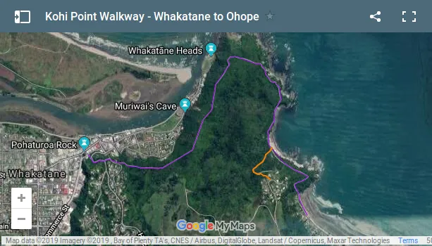
Since the nice weather stayed with us, I decided to go on a hike into the hills surrounding Whakatane. There is an 11 km long loop called Nga Tapuwae o Toi (on the footsteps of Toi), which took me up to a nice look-out point above the town, then on to an elevated spot above The Heads, from there it looped around a picturesque bay to the neighboring beach town of Ohope, where I met my parents rode back with them to Whakatane.
Kapu Te Rangi, The Site of Toi’s Pa
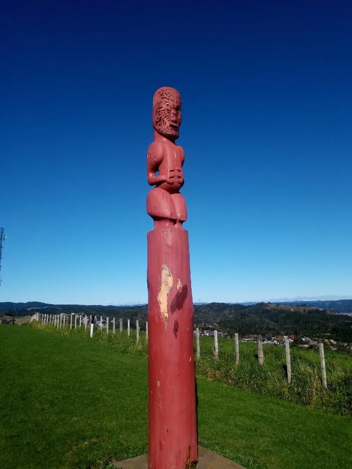
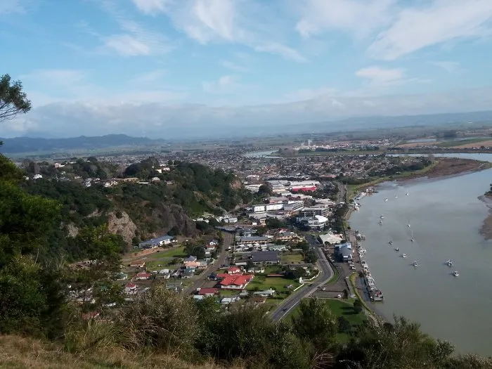
The trail gets its name from Toi, one of the most prominent chieftains in the area, who set up his pa, or fortified compound, on the hill overlooking the town. This hill is also known as Kapu te Rangi, which means Pa of Gentle Breezes. The first section of the trail starts from the top of the stairs featuring the world’s fist vertigraph, and is a leisurely 15-20 minute walk. It also passes the Wairere Stream, just above the famous falls. When I visited my parents ten years ago, they lived right on Toi Street, only one block from the trailhead. Today their house is not much further, so it didn’t take more than an hour to walk up to the Kapu te Rangi and back. Though there are no traces of Toi’s pa left today, a carved pole indicates its former location, from where the entire town can be seen.
A Long Series of Explorations
According to the local lore, Toi was a traveler who came to Aotearoa looking for his grandson, another ancient traveler, crossing the Pacific like other people cross their street. Toi didn’t find his grandson, but he settled the local area with his family. This happened about two centuries before the arrival of the Mataatua, and the heroic action of Wairaka, I described in an earlier post. They were also the same people who brought the sweet potato with them from Hawaiki (Hawaii).
The Arrival of the Sweet Potato
As the story goes, the descendants of Toi found two young men washed up on the shore. Their names were Hoaki and Tuakata, also travelers from Hawaiki, the ancient Maori homeland. They had suffered shipwreck just as they were about to reach the Land of the Long White Cloud, so the locals scooped them up from the shore, and took them to the pa up on the Kapu te Rangi. There they fed them the local specialty, a meal of pounded fern root, which the two men who had regained their senses were not very fond of. Instead they offered the locals some dried Kumara, or sweet potato, which they managed to save from their shipwrecked vessel. This delicious treat found such an appeal with Toi’s offspring, that the next day Hoaki and Tuakata started building a waka (boat) to return to Hawaiki, in order to bring more of it to Aotearoa. A generation later this nutritious crop arrived on the Mataatua.
Kohi Point Lookout
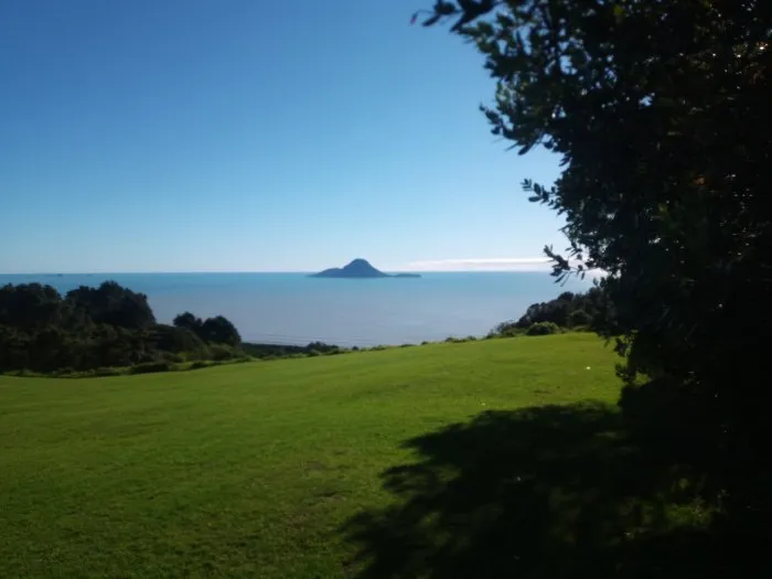
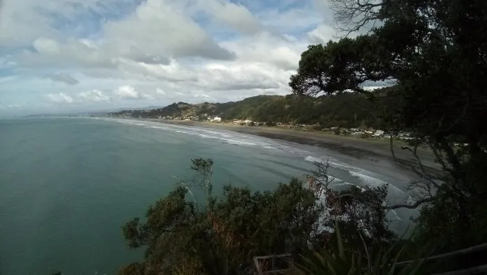
Leaving the the site of Toi’s pa on the Kapu te Rangi, the trail loops out towards the sea to the Kohi Point, on the hills just above the Whakatane Heads, forming a small peninsula in the ocean. This offers a gorgeous lookout over the Whakatane River, and the Eastern part of the town, including the Irakewa Rock with Wairaka’s statue. In the distance Mount Edgcumbe or Putauaki can be seen to the Southwest, and far out at sea White Island or Whakaari. Even though there was no cloud in the sky, I could only guess White Island’s whereabouts. The island just off the coast of Whakatane is called Whale Island, and is a bird sanctuary, off limits to pesky visitors.
Supposedly the entire hill had been one large pa, that is a series of fortifications. Though today nothing of it remains, an informative sign gives hikers an idea what this place must have been like in the days of Toi: buildings and open spaces surrounded by a palisade fence, and broken up into various sections to make defending it more efficient.

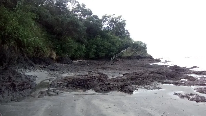
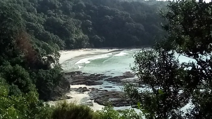
To Ohope across Otarawairere Bay
Once past the Kohi Point the hike becomes more natural than cultural. It turns South again, descending into picturesque Otarawairere Bay, which is only accessible during low tide, as the trail leads right over the rocks and sand of the bay. At high tide the hiker would be forced to swim this distance, which may not be easy, and is not considered safe. Fortunately, I got there at the perfect time, and I enjoyed a lovely walk, reaching the other side of the bay dry-footed.
From here it was just another short hike up the next hill, and down on the other side onto the long beach of Ohope. Unlike Whakatane, this small town has a humongous beach, which can take hours to walk down completely. I may still come back to it, and complete the other side of the loop back to Whakatane via the Bird Walk over Fairbrother and Mokurora Gorge. This time, however, I met up with my folks on the beach, and we took the car back to Whakatane.
Take a Look at the Rest of my Series Wonders of Whakatane:
- An Excursion to the Origins
- On the Footsteps of Toi
- The Ohope Scenic Reserve
- White Island, Where the Devil Goes on Vacation
- Birds in my Mom’s Garden
- Nativism, a Destructive Form of Environmentalism
- The World's First Vertigraph
- Local Murals of Whakatane
- The Deeds of Legendary Maui
Please check out these great communities I'm contributing to:

#ecotrain | What is EcoTrain | Discord Community

#tribesteemup |The 8 Pillars of @TribeSteemUp


#cyclefeed | Introducing CycleFeed | Discord Community