Alberto Tropical Storm Warnings West & North Florida Coasts to Alabama
<iframe style="border: none;" src="//rcm-na.amazon-adsystem.com/e/cm?o=1&p=12&l=ez&f=ifr&linkID=431c1e7be66bc52a4e7193969dcff192&t=meteorologisj-20&tracking_id=meteorologisj-20" width="300" height="250" frameborder="0" marginwidth="0" scrolling="no"></iframe>
Alberto Tropical Storm Warnings West & North Florida Coasts
Westward to Alabama Mississippi Border
A Tropical Storm Warning has been issued for the west coast of the Florida peninsula from Bonita Beach to the Anclote River.A Tropical Storm Warning has been issued for the northern Gulf Coast
from the Aucilla River westward to the Mississippi/Alabama border.The Tropical Storm Watch has been discontinued west of the Mouth of
the Pearl River including Lake Pontchartrain and Lake Maurepas.The Storm Surge Watch has been discontinued to the west of the
Mouth of the Pearl River.Alberto remains a rather sheared looking subtropical cyclone as it continues its slow northward motion. Looking at the visible satellite loop below it appears that a new center has formed in the Southeast Gulf of Mexico and that will likely become the main center as it moves northward at about 13 mph.
The National Hurricane Center has issued tropical storm warnings now for the west coast of Florida since Alberto has much more going on east of the center with convection continuing to burst over Southern Florida. Gales could affect immediate coastal areas overnight and on Sunday. Gradually Alberto is going to become more tropical as it strengthens as conditions are favorable over the next 36 hours or so. Upper air winds are forecast to relax and Alberto will be responding to a deep trough and cut off low ni the upper atmosphere that is forecast to form in the Northern Gulf of Mexico.
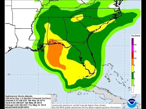
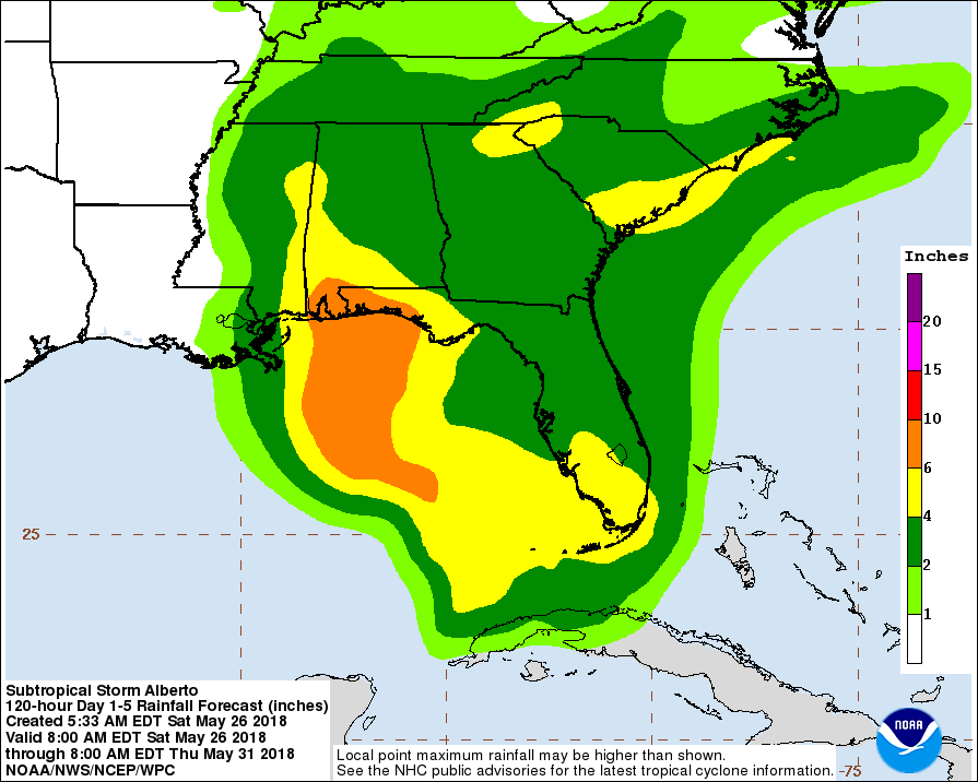
WPC RAINFALL FORECAST THROUGH MONDAY EVENING
Heavy rain remains the primary focus here especially over Florida where another 4 inches of more of rain is possible over South Florida. Then another heavy rain axis develops near where the circulation makes landfall. This seems to make sense given the dynamics involved and the deep tropical connection that continues from the Northwest Caribbean northward across Florida and into the Southeast US.
The NAM model overnight swamps Florida with bands of rain and weather models show the storm organizing overnight into Sunday. Alberto will be moving over very warm water temperatures in the Northern Gulf of Mexico and it could strengthen further before landfall. Right now it would seem landfall will be somewhere east of Mobile to the Northwest Florida coast sometime during Monday.
For more specific information you can access the National Hurricane Center website or your local National Weather Service forecast office.
FiOS1 News Weather Forecast For Long IslandFiOS1 News Weather Forecast For New Jersey
FiOS1 News Weather Forecast For Hudson Valley
NATIONAL WEATHER SERVICE SNOW FORECASTS
JOIN JOESTRADAMUS ON YOUTUBE!LATEST JOESTRADAMUS ON THE LONG RANGE
NEW YORK WEATHER
<script type="text/javascript">
amzn_assoc_placement = "adunit0";
amzn_assoc_search_bar = "true";
amzn_assoc_tracking_id = "meteorologisj-20";
amzn_assoc_search_bar_position = "bottom";
amzn_assoc_ad_mode = "search";
amzn_assoc_ad_type = "smart";
amzn_assoc_marketplace = "amazon";
amzn_assoc_region = "US";
amzn_assoc_title = "Shop Amazon Via JOESTRADAMUS for anything. Just Use The Search Box";
amzn_assoc_default_search_phrase = "fishing gear";
amzn_assoc_default_category = "All";
amzn_assoc_linkid = "400feb49ec86e057a1495ab9f8e2ac47";
</script>
<script src="//z-na.amazon-adsystem.com/widgets/onejs?MarketPlace=US"></script>
Posted from my blog with SteemPress : http://www.meteorologistjoecioffi.com/index.php/2018/05/26/alberto-tropical-storm-warnings-west-north-florida-coasts-to-alabama/