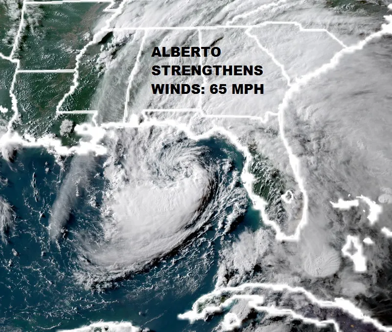
Alberto Strengthens Winds 65 MPH Moving Toward NW Florida
<iframe style="border: none;" src="//rcm-na.amazon-adsystem.com/e/cm?o=1&p=12&l=ez&f=ifr&linkID=431c1e7be66bc52a4e7193969dcff192&t=meteorologisj-20&tracking_id=meteorologisj-20" width="300" height="250" frameborder="0" marginwidth="0" scrolling="no"></iframe>
Alberto Strengthens Winds 65 MPH Moving Toward NW Florida

During the afternoon & evening hours satellite loops show that Alberto continues to organize and is beginning to look more like a tropical rather than a subtropical storm. Recent reports from an Air Force plane show that maximum winds are now 65 mph and the pressure has fallen to 991 millibars. Alberto is nearing the NW Coast of Florida but landfall will not happen until Monday afternoon at the earliest. The storm is responding to a cut off upper low that is developing in the North Central Gulf which may slow it down a bit. A light wind shear environment aloft could create an opportunity for further strengthening. There is a chance Alberto could become a minimal hurricane before landfall making it only the 5th such hurricane in May since 1851!

The way the short term models see this like the HRRR & the NAM, the storm at 10am Monday is still offshore with a radar presentation that appears like a well defined core of convection near the center. The northern most band of rain that has separated from the core reaches into the Carolina's Monday morning. Also some rain is still showing up in Southeast Florida.

On the Southern Mississippi Valley regional radar you can see bands of rain in Northwest Florida but you can also begin to see a ring of echos offshore that represents the strengthening center. The National Hurricane Center which has been in a tough spot from the beginning with this system coming on a holiday weekend will be facing a dilemma regarding whether hurricane warnings may be required. We will await their latest advisory which should be out within the hour.
FiOS1 News Weather Forecast For Long IslandFiOS1 News Weather Forecast For New Jersey
FiOS1 News Weather Forecast For Hudson Valley
NATIONAL WEATHER SERVICE SNOW FORECASTS
JOIN JOESTRADAMUS ON YOUTUBE!
LATEST JOESTRADAMUS ON THE LONG RANGE
NEW YORK WEATHER
<script type="text/javascript">
amzn_assoc_placement = "adunit0";
amzn_assoc_search_bar = "true";
amzn_assoc_tracking_id = "meteorologisj-20";
amzn_assoc_search_bar_position = "bottom";
amzn_assoc_ad_mode = "search";
amzn_assoc_ad_type = "smart";
amzn_assoc_marketplace = "amazon";
amzn_assoc_region = "US";
amzn_assoc_title = "Shop Amazon Via JOESTRADAMUS for anything. Just Use The Search Box";
amzn_assoc_default_search_phrase = "fishing gear";
amzn_assoc_default_category = "All";
amzn_assoc_linkid = "400feb49ec86e057a1495ab9f8e2ac47";
</script>
<script src="//z-na.amazon-adsystem.com/widgets/onejs?MarketPlace=US"></script>
Posted from my blog with SteemPress : http://www.meteorologistjoecioffi.com/index.php/2018/05/27/alberto-strengthens-winds-65-mph-moving-toward-nw-florida/