Our storm is getting underway this morning with radars expanding and snow breaking out now. Gradually snow will get heavier this morning and the heaviest will be later this afternoon and through the first half of tonight. I did a little nudging up on snow amounts late last night and this is where we are this morning with the snow forecast. No changes are being made. Please note that I continue to remain 50% lower than the National Weather Service snow amounts.
US SATELLITE
REGIONAL RADAR
LOCAL RADAR NEW YORK CITY
LOCAL RADAR PHILADELPHIA
Weather models overnight didn't really change too much. Looking at the how this will progress today with the heaviest snows to fall later this afternoon until about 3 or 4am, this snow is going to accumulate on all surfaces. Until the heavy snow gets going most main roads will be wet. Temperatures will settle in the lower 30s.
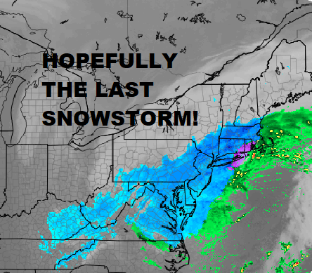
NAM FORECAST SATELLITE RADAR 8PM WEDNESDAY 3/21/2018
The map above is what the NAM forecasts the satellite and radar to look like at 8pm tonight. The snow bands extend well inland of the coast at this point with the darker blue radar echos evident over a large area. Even at 8am Thursday the western edge band is still right along the coast.
Once this storm moves away weather conditions improve on Thursday and it will be chilly and mostly dry into Saturday. There could be a snow shower late Thursday and again late Friday. The weekend looks good. The next storm system dropping out of the Plains should pass to our south over the weekend with little issue. Long range at least shows no other noreasters coming as we wrap up this remarkable month of March. I won't speak yet about April.
Posted from my blog with SteemPress : http://www.meteorologistjoecioffi.com/index.php/2018/03/21/winter-storm-warning-washington-dc-to-boston-springwinterstorm/
Winter Storm Warning Washington DC To Boston #Springwinterstorm | Ecency
Frigid Day Today Classic Setup Classic Questions Early Weekjoewxman ·