
Welcome to this edition of
California Mountain Adventures!!
I want to share the #amazingnature I see on my wilderness adventures with all the nature lovers here on Steem so this edition is also going to be an entry for  @adalger's
Amazing Nature Contest!!
Join the contest and share your #amazingnature!
In this adventure I head deep into the Sierra Nevada mountains for a rather wild trip to...
Cloud Canyon!!
Larry(
Marvin Pass trailhead
Entering the Jennie Lakes Wilderness at Marvin Pass
Wildflowers along the trail
Meadows by Mitchell peak
Our first camp
It rained on us a little and we got some lightning and thunder. But it didn't last long. We watched the storm break and then we decided that we still had enough time in the day to climb up the trail to Mitchell peak(10,365')! The climb up was pretty easy, but the storm looked like it could come back at any moment. We got to the peak and enjoyed what views we could get through all the clouds. Views of Kings Canyon, Sugarloaf Valley, and the Silliman crest. Then it started to lightly sprinkle on us so we started back down. We took a direct cross country route down the south side of the peak back to our camp at the meadow.
Views from Mitchell peak
Views from Mitchell peak
Back down at the meadows
The next morning the bugs were horrible! We packed up camp and headed up and over Kanawyer gap, into Kings Canyon national park, and dropped down by Commanche meadow and into Sugarloaf valley. We made the long trek across Sugarloaf valley crossing Sugarloaf creek and Ferguson creek. Once again we had a storm building quickly. We climbed up and over a ridge and down to the Roaring river. As we were descending down to the river it started raining again. The rain got harder, and harder, and harder. At one point I felt like I was literally standing under a waterfall!! We tried to push on. Hoping for a break in the storm... but it never came. Eventually we found a spot by the river and decided to setup our camp in the rain. I got a huge puddle in my tent, but it was good to get out of the pounding rain. I used a small ziplock bag to scoop most of the water out of my tent. And finally, at the very end of the day, the rain subsided.
Trail junction
Commanche meadows
Creek crossing on a log
Sugarloaf Creek
Climbing over the ridge to Roaring River
The Roaring River
Camping in the rain
The next morning we packed up camp and headed up Roaring river passed the ranger station, over the bridge, across Brewer creek and Barton creek, passed Cement table meadow to Big Wet meadow. The bugs were brutal all morning, but actually weren't that bad at Big Wet meadow (contrary to what some equestrians that we passed on the trail had told us) so we stopped there to have some lunch and enjoy the awesome views of Whaleback! After lunch we hiked through the meadow and started making our way up Cloud Canyon. For the third day in a row, we had a storm building fast and before we knew it we were getting dumped on again. We had to make a couple gnarly fords of the river and then we left the trail and started climbing cross country into the upper canyon. Bushwhacking, mud, talus, and pounding rain made the climb super tough. And when we were about a mile from the spot where we were supposed to meet Mike and Rogue, Larry lost all his energy and had to stop. He found a spot and setup his camp and I continued on up the canyon. I got up to where Mike and Rogue were setup and had one last gnarly river ford to get to them. For a second I thought it might actually wash me away! But it didn't, and I made it safely across to their camp. They were both really surprised to see me given the horrible weather conditions. I setup my tent and then got caught up with my friends. I told them about me and Larry's rain and bug filled trek. And heard all about their wild trek up Deadman canyon and over Glacier ridge.
Roaring River
Brewer Creek
Passing a pack train
Cement Table meadow
Cement Table Meadow
Shooting Stars in Big Wet meadow
Indian Paintbrush in Big Wet meadow
River crossing
Climbing up Cloud Canyon
Climbing up Cloud Canyon
Crossing a snowfield in upper Cloud Canyon
Upper Cloud Canyon
Camping in Upper Cloud Canyon
Upper Cloud Canyon
Dinnertime with Rogue and Mike
Our plan had originally been to climb Whaleback, a gnarly peak that overlooks Cloud Canyon, but with all the bad weather we all knew that it wasn't gonna happen this trip. So the next morning we packed up camp and headed down canyon and met up with Larry. We made our way back down the canyon stopping briefly at Big Wet meadow for a trout fishing break. As we headed down river it started raining again so we stopped at the Roaring river ranger station where we huddled under the overhang on the porch to get ourselves out of the rain for a little bit. Then once the rain passed we headed another mile or so down river to a really nice camping spot along the river where we got a nice big campfire going and hung up all our wet stuff to dry. We made dinner had some drinks and marveled at the insane amount of mosquito bites that Larry had gotten over the last few days!
Morning light from my tent
Heading back down Cloud Canyon
Shorty's Cabin
Big Wet meadow
Catching a Golden trout
Big Wet meadow
Roaring River ranger station
Camping by Roaring river
Roaring river
Larrys mosquito bites
*photo by Rogue Photonic used with permission
The next morning we climbed back up and across Sugarloaf valley. Rogue and Mike decided to push it and hike all the way out in one day, but Larry and I opted for one last night by Commanche meadow. We found a great spot to setup camp and then I headed out for some trout fishing on Sugarloaf creek. For the most part the creek in this section was really overgrown with brush which made fishing kinda hard, but with some effort I was able to snag some nice trout and even decided to keep a couple to cook up with dinner! The bugs were still horrible, but at this point we were totally used to it. Luckily they weren't biting me nearly as much as Larry. I must have some sour blood!
Re-crossing Sugarloaf valley
Sugarloaf creek
Trout dinner
Larry hanging out at camp
After enjoying a fun last night out, we packed up camp and headed up the trail. On our way out we decided to take the route through Rowell meadow instead of going over Kanawyer gap which saved us from climbing as much elevation. From Rowell meadow we climbed back over Marvin pass and down to the trailhead at Horse meadows. Needless to say with all the rain and the bugs it was a brutal trip, but we still had a lot of fun. As I often like to say... it's all part of the adventure!!
Trailside fungi
Crossing the Kings Canyon park boundary on our way out
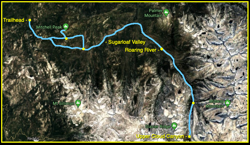
Map(click to enlarge)
And that's going to be it for this
California Mountain Adventure!
*all photos by 
[//]:# (!steemitworldmap 36.619999 lat -118.540677 long Cloud Canyon d3scr)
Steemit World Map
Contact me on Discord
#SoCalSteemit is building and supporting the Steemit community of Southern California. If you are from SoCal and are into creating quality content here on Steemit, we'd love for you to follow us @SoCalSteemit and join our group on Discord
Animation By 