I have been feeling gloomy last week, maybe because of the weather, and it really affected my overall productivity in life. I missed the mountains so much. The feeling of being drenched in sweat while catching my breath as I make my way to the peak or being soaked in the rain, I want to feel those again. I missed the cold and exposure to the elements of nature, but I don't know when I could experience those things again. My only solace this time is to reminisce my previous climb. I haven't featured Camiguin yet so that's what I'll do in the coming days. Our climb to Mt. Hibok-Hibok is first in the list.
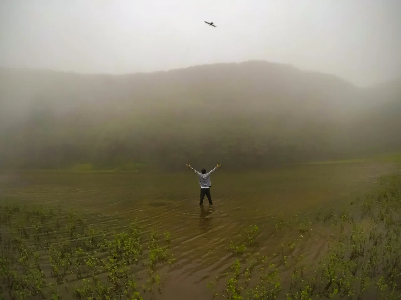 Standing knee-deep at Aaron Lake. Aaron Lake is located at the crater of Mt. Hibok-Hibok in Camiguin Island.
Hello Hive!
It's time for another Kim's Quest! I think it's been a month since the last quest which was all about the mystical island of Siquijor. As promised, it's now time for the island of volcanoes - Camiguin Island.

Did you know that Camiguin is the island with the highest volcano concentration per square kilometer in the country?
[1] For such a small land area, it has 10 volcanoes! That's double the number of towns the island-province has! Camiguin has 5 towns namely: Catarman, Guinsilaban, Mahinog, Mambajao, and Sagay.
[2]
In this quest, I'll be taking you to a trip down to memory lane. I missed this kind of way of packaging my post. I have to apologize ahead for the photos though. They're not the best because of the rain and fog that greeted us on our way to the summit.

Our climb to Mt. Hibok-Hibok was special to me. It's one of the tourist spots here in the Philippines that's included in our social studies books when I was in elementary, like Chocolate Hills and Banaue Rice Terraces. Since then, it has been one of my goals in life to visit these places. When we had the opportunity to climb Mt. Hibok-Hibok, I made sure that I wouldn't miss that opportunity.
I actually wrote something about this a long time ago, but those were bonkers. I just felt it was not done out of necessity to post something, so I edited all the photos and decided to write about it again. Anyway, you can find them here:
So there I was, waken up on the sound of my alarm. It was the second day of our stay in Camiguin and the day before was laden with adventures in touristy places. I was still very tired and groggy, but I had to wash my face and brush my teeth. It was still 4:00 AM, but they said our transportation and guides were already waiting for us outside. We had to be at the jump-off point at 4:30 AM.

While on the jeepney to the jump-off point, I was zoning in and out, as much as I felt during the past week. I felt that I was not really ready for the climb, but there's no backing out. We arrived at the starting point of the climb and I have no idea where it was located on the map. There was no signal and my Google Maps was not working. All I knew was that we were already at a certain elevation above sea level. I was still sleepy, but our guide said that we should start the assault.
The Assault

I knew that we were still in private lands because there were still coconut trees and the trail was well kept. It was still dark and cold. I was fighting against tiredness and sleep as I wade my way through the bushes. I knew it was very windy, but only at the canopy of the trees. The wind barely reached us as we continued the assault.

We were barely past the private lands when it started to drizzle. At that moment I prepared myself for a gruelling ascent. I had scaled minor climbs in Cebu before that, but it was my first time to try a medium-difficulty climb.
We entered a protected forest area at around 5:00 AM, but it was still very dark that it was impossible to see the trail without our flashlights on. Judging from the canopy and trunk of the trees, I thought they're planted there. They're most likely mahogany trees.

As we continued our climb, it became harder to breathe. My steps became smaller and slower as the trail became steeper and steeper. I had to focus all my energy just to make one step. I realized I was not the only one who had the difficulty because some of my workmates already requested to rest.

As we were about to enter a virgin forest, the rain poured so hard. Wind and fog multiplied the difficulty of the climb. It became a never-ending assault with the most extreme weather condition. Mt. Hibok-Hibok was classified as 4/9 in level of difficulty, but there was no way of classifying the level of difficulty during that time. Rain and mud rushed like a stream as we continued our assault.

As we reached the mossy forest near the mouth of the crater, it became more difficult to climb because of the ankle-deep mud. It was around 7:00 AM when we reached the mouth of the crater. It was 1107 meters above sea level. I was cold, drenched in rainwater, and very tired. I had difficulty in breathing, but we still had to descend about 100 meters before reaching the crater.
Aaron Lake [Mt. Hibok-Hibok Crater Lake]

As we descended towards the crater lake, I observed that the wind became stronger and I felt so cold that I couldn't feel the extremities of my fingers. As we reached a clearing, our guide told us that were already at the crater. The crater is a flat area with a lot of grasses and plants. We continued walking until we reached the lake.

Aaron Lake is the accumulation of surface run-off from the mouth of the crater. It's not too deep though. The fog made the whole place so surreal that it was worth all the hassle to climb. It was really windy that I decided to wrap myself with a thermal blanket after the mandatory photoshoot. Without a thermal blanket, I would have given up to the cold.

We should have to ascend again towards the peak of Mt. Hibok-Hibok, but because of the wind and fog, our guide decided to cancel the plan. It would be useless anyway since we won't be able to see the whole island from that point because of the fog.

After we got satisfied with our stay at the crater, we decided to start the descent. The rain had stopped, but the wind and fog were still there, making the whole place look mysterious. When you're at the center of the crater, it really feels amazing to be surrounded by mountains on all sides.
We traversed the same trail during ascent, but it was more difficult during descent. It was really muddy and one wrong move could send us down the slippery slope. It took us a total of 7 hours hike from the starting point to the crater and then back to the starting point.
Parting Words

This climb taught me to never underestimate mental fortitude and preparedness. Of course, physical preparedness is equally important, but you have to condition your mind to never give up in situations like that. Also, I learned not to underestimate every climb no matter how easy it is. As @xaydtrips had put it, a 1/9 level of difficulty could become 9/9 depending on the weather and your level of preparation.
Alright! That's all for this post. Stay tuned for the next posts about Camiguin. It might be about our island hopping adventure or about our tour around the island. See you in the next post!
References:
[1]https://www.dost.gov.ph/knowledge-resources/news/37-2010-news/317-phivolcs-dost-digital-tech-wires-island-volcanoes-in-real-time.html
[2]https://geographic.org/streetview/philippines/region_10/camiguin.html
Kim Ybañez
Welcome to Kim's small corner in Hive. He is a chemical engineer by profession, but a blogger by passion. He is a wanderlust and an adventure seeker. Join his quests as he visits secluded destinations, climbs mountains, tries new and exotic dishes, and explores his country (The Philippines) and the rest of the world even if he's still a poor corporate slave with tons of bills to pay and two siblings to support in college.
If you like his content, don't forget to upvote and leave a comment to show some love. You can also reblog if you want to. Also, don't forget to follow him to be updated with his latest posts.